IMAGES TAKEN NEAR TO
Market Street, RUTHIN, LL15 1AU
Introduction
This page details the photographs taken nearby to Market Street, LL15 1AU by members of the Geograph project.
The Geograph project started in 2005 with the aim of publishing, organising and preserving representative images for every square kilometre of Great Britain, Ireland and the Isle of Man.

There are currently over 7.5m images from over14,400 individuals and you can help contribute to the project by visiting https://www.geograph.org.uk
Image Map
Images are licensed for reuse under creativecommons.org/licenses/by-sa/2.0
Notes
- Clicking on the map will re-center to the selected point.
- The higher the marker number, the further away the image location is from the centre of the postcode.
Image Listing (392 Images Found)
Images are licensed for reuse under creativecommons.org/licenses/by-sa/2.0
Image
Details
Distance
1
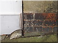
Bench mark on 10 Market Street, Ruthin
This small bench mark is on the corner of number 10 Market Street/Stryd y Farchnad. Part of the arrowhead has been filled with mortar.
Image: © John S Turner
Taken: 17 Jan 2010
0.01 miles
2
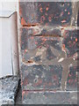
Ordnance Survey Cut Mark
This OS cut mark can be found on No10 Market Street. It marks a point 62.097m above mean sea level.
Image: © Adrian Dust
Taken: 8 Aug 2015
0.01 miles
3
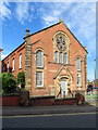
Capel Bathafarn, Market Street, Ruthin
Capel Bathafarn stands on the corner of Market Street and Mount Street, Ruthin. It was built in 1869, and for more history of the chapel see Eirian Williams' photo: Image
Image: © John S Turner
Taken: 18 Sep 2018
0.02 miles

5
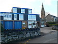
Ruthin Ambulance Station
Situated on Ffordd Yr Ysgol. The spire is that of St Peter's Church.
Image: © Eirian Evans
Taken: 17 Jan 2009
0.02 miles
6
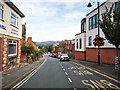
Ruthin - Market Street
View north with the Clwydian Range on the horizon.
Image: © James Emmans
Taken: 21 Aug 2019
0.02 miles
7

A GR postbox in Ruthin
This GR postbox is set into the wall between School Road and Troed y Rhiw, Ruthin. Its reference number is LL15 40D.
Image: © John S Turner
Taken: 18 Sep 2018
0.04 miles
8

Ruthin from Bryn Goodman
Looking west towards Ruthin from the road named Bryn Goodman.
Image: © John S Turner
Taken: 18 Sep 2018
0.05 miles
9
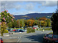
Bottom of Market Street, Ruthin
Market Street ends in a roundabout with adjacent car park. Most of the area was once the station yard, with the station building situated where the trees are now. In the distance is the distinctive summit of Moel Famau.
Image: © Nigel Brown
Taken: 18 Oct 2004
0.05 miles
10
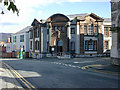
County Hall, Ruthin
This is the original building; a much larger modern range of offices now lies behind it.
Image: © Nigel Brown
Taken: 18 Oct 2004
0.05 miles