IMAGES TAKEN NEAR TO
Mona Terrace, WREXHAM, LL14 6NY
Introduction
This page details the photographs taken nearby to Mona Terrace, LL14 6NY by members of the Geograph project.
The Geograph project started in 2005 with the aim of publishing, organising and preserving representative images for every square kilometre of Great Britain, Ireland and the Isle of Man.

There are currently over 7.5m images from over14,400 individuals and you can help contribute to the project by visiting https://www.geograph.org.uk
Image Map (Loading...)


Getting Data...Please wait
Leaflet Map data © OpenStreetMap
Images are licensed for reuse under creativecommons.org/licenses/by-sa/2.0
Notes
- Clicking on the map will re-center to the selected point.
- The higher the marker number, the further away the image location is from the centre of the postcode.
Image Listing (215 Images Found)
Images are licensed for reuse under creativecommons.org/licenses/by-sa/2.0
Image
Details
Distance
1
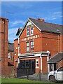
Rhiwabon
Nowhere is the brilliant red Ruabon brick better shown off than in its home village on a bright early spring morning.
Image: © Mike Parker
Taken: 1 Mar 2022
0.04 miles
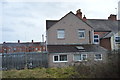
3
Houses & shops on Rhiwabon high street
The A483 used to pass through here, now it is just a busy village centre. Large house to the right, shops to left (looking very like houses) and the large terrace houses beyond would have been "best end" housing pre-1939.
Image: © John Haynes
Taken: 24 Mar 2012
0.07 miles
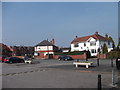
4
Solar Signals
Whilst appearing to be haphazardly placed these solar powered signals carry out a very important function.
Image: © Geoff Evans
Taken: 11 Mar 2010
0.08 miles
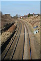
5
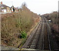
Railway from Ruabon towards Wrexham
The Shrewsbury to Chester Line northeast of this http://www.geograph.org.uk/photo/4851186 stone bridge. Next station ahead is Wrexham General.
Image: © Jaggery
Taken: 27 Feb 2016
0.09 miles
6
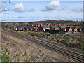
Ruabon over the Railway
The Chester to Shrewsbury line as it passes through Ruabon
Image: © Eirian Evans
Taken: 19 Mar 2008
0.09 miles
7
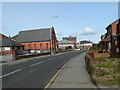
High Street, Ruabon
The B5605 through Ruabon. On the left is Ruabon Methodist Church, formerly a Primitive Methodist Sunday School built in 1892.
Image: © Eirian Evans
Taken: 19 Mar 2008
0.09 miles
8
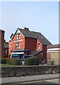
The Stores, Ruabon
On Henry Street, Ruabon
Image: © Eirian Evans
Taken: 19 Mar 2008
0.10 miles
9
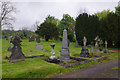
Ruabon Cemetery
This small village cemetery is accessed via Church Street. It is operated by Ruabon Community Council.
Image: © Stephen McKay
Taken: 9 May 2019
0.11 miles
10
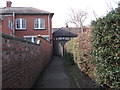
Urban footpath
This footpath has come from open country on Wat's Dyke to the confines of the buildings on a village high street. The barred building on the left is the HSBC bank with offices to the right.
Image: © John Haynes
Taken: 24 Mar 2012
0.12 miles