IMAGES TAKEN NEAR TO
West End Terrace, WREXHAM, LL14 6EA
Introduction
This page details the photographs taken nearby to West End Terrace, LL14 6EA by members of the Geograph project.
The Geograph project started in 2005 with the aim of publishing, organising and preserving representative images for every square kilometre of Great Britain, Ireland and the Isle of Man.

There are currently over 7.5m images from over14,400 individuals and you can help contribute to the project by visiting https://www.geograph.org.uk
Image Map (Loading...)


Getting Data...Please wait
Leaflet Map data © OpenStreetMap
Images are licensed for reuse under creativecommons.org/licenses/by-sa/2.0
Notes
- Clicking on the map will re-center to the selected point.
- The higher the marker number, the further away the image location is from the centre of the postcode.
Image Listing (214 Images Found)
Images are licensed for reuse under creativecommons.org/licenses/by-sa/2.0
Image
Details
Distance
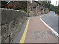
1
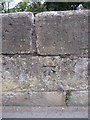
Bench mark on Pont Adam, Ruabon
This bench mark is on the north parapet of the old stone bridge, Pont Adam, that carries the B5079, also called Pont Adam, over the Afon Eitha. The mark was recorded on the 1874 O.S. map, levelled at 379.5 feet. See also Image]
Image: © John S Turner
Taken: 10 Sep 2011
0.01 miles
2
Pont Adam and a bench mark
Looking along and across Pont Adam with a bench mark on the left hand side - Image
Image: © John S Turner
Taken: 10 Sep 2011
0.01 miles
3
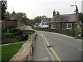
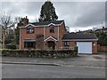
Pont Adam, Ruabon
Looking along the B5097, which is called Pont Adam the same as the old stone bridge. The bridge spans Afon Eitha, and Corner Cottage is on the right.
Image: © John S Turner
Taken: 10 Sep 2011
0.01 miles
4
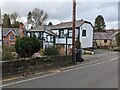
Public footpath
Public footpath to the south, which I couldn't see marked on any maps, but is clearly signposted on the ground. It's not new and signs have been in place for at least 15 years.
Image: © TCExplorer
Taken: 4 Mar 2024
0.01 miles
5
Faded sign, Pont Adam, Ruabon
Facing the B5097 Pont Adam, a faded signpost arm points left towards a path to Ruabon railway station.
Image: © Jaggery
Taken: 27 Feb 2016
0.02 miles
6
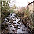
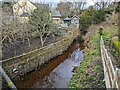
Small waterfall in the Afon Eitha, Ruabon
Southeast of the B5097 Pont Adam, viewed from the bridge carrying a path to Ruabon railway station.
Image: © Jaggery
Taken: 27 Feb 2016
0.02 miles
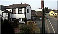
7
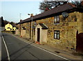
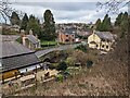
Row of three stone cottages, Pont Adam, Ruabon
On the east bank of a river, the Afon Eitha, a tributary of the River Dee.
Image: © Jaggery
Taken: 27 Feb 2016
0.02 miles