IMAGES TAKEN NEAR TO
Little Street, WREXHAM, LL14 6DF
Introduction
This page details the photographs taken nearby to Little Street, LL14 6DF by members of the Geograph project.
The Geograph project started in 2005 with the aim of publishing, organising and preserving representative images for every square kilometre of Great Britain, Ireland and the Isle of Man.

There are currently over 7.5m images from over14,400 individuals and you can help contribute to the project by visiting https://www.geograph.org.uk
Image Map (Loading...)


Getting Data...Please wait
Leaflet Map data © OpenStreetMap
Images are licensed for reuse under creativecommons.org/licenses/by-sa/2.0
Notes
- Clicking on the map will re-center to the selected point.
- The higher the marker number, the further away the image location is from the centre of the postcode.
Image Listing (227 Images Found)
Images are licensed for reuse under creativecommons.org/licenses/by-sa/2.0
Image
Details
Distance
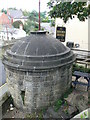
1
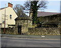
Grade II listed former village lockup, Bridge Street, Ruabon
The 18th century roundhouse near the Vaults pub http://www.geograph.org.uk/photo/4842816 (formerly the Roundhouse pub)
has small openings in the wall with iron bars across. This was the village lockup, which was used for the temporary detention of people, typically drunks who were usually released the next day. It was also used to hold people being brought before the local magistrate. The building was Grade II listed in 1963.
Image: © Jaggery
Taken: 27 Feb 2016
0.02 miles
2
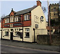
The Vaults, Ruabon
The Bridge Street pub was previously named the Roundhouse.
http://www.geograph.org.uk/photo/4842825 to a view of The Vaults name sign.
The tower of St Mary's church http://www.geograph.org.uk/photo/4846419 is in the background.
Image: © Jaggery
Taken: 27 Feb 2016
0.02 miles
3
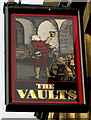
The Vaults name sign, Ruabon
On a wall bracket here. http://www.geograph.org.uk/photo/4842816
Image: © Jaggery
Taken: 27 Feb 2016
0.02 miles
4
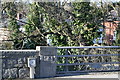
Misleading milestone
This obscure milestone , part of the river bridge wall, not easily seen by motorists, states 5 miles to Wrexham.
Image: © Geoff Evans
Taken: 11 Mar 2010
0.02 miles
5
The Round House, Ruabon
An 18th C lock up where drunks and miscreants were locked up for the night.
Image: © Eirian Evans
Taken: 26 Sep 2007
0.02 miles
6
Bridge over the River Eitha, Ruabon
The bridge connects Duke Street and Paddock Row with the B5605 Bridge Street on the left.
The Eitha flows into the River Dee near Chirk.
Image: © Jaggery
Taken: 27 Feb 2016
0.02 miles
7
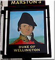
Duke of Wellington name sign, Ruabon
On the wall here. http://www.geograph.org.uk/photo/4843200
Image: © Jaggery
Taken: 27 Feb 2016
0.02 miles
8
The Vaults pub and a roundhouse, Ruabon
Located on the B5605 Bridge Street. The roundhouse is possibly the more interesting building here, as it was a village lock-up, an overnight jail for drunks and ne'er-do-wells. The building is appropriately placed near to at least three pubs, as well as the church. They may be expected to perform a hungover prayer of forgiveness, afterwards.
Image: © El Pollock
Taken: 11 Jun 2014
0.02 miles
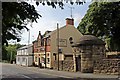
10
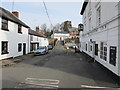
Duke Street, Ruabon
North along Duke Street from the corner of Paddock Row. http://www.geograph.org.uk/photo/4843215
The Duke of Wellington http://www.geograph.org.uk/photo/4843200 is on the right.
Image: © Jaggery
Taken: 27 Feb 2016
0.02 miles