IMAGES TAKEN NEAR TO
Llwyn Y Berllan, LL14 6AZ
Introduction
This page details the photographs taken nearby to Llwyn Y Berllan, LL14 6AZ by members of the Geograph project.
The Geograph project started in 2005 with the aim of publishing, organising and preserving representative images for every square kilometre of Great Britain, Ireland and the Isle of Man.

There are currently over 7.5m images from over14,400 individuals and you can help contribute to the project by visiting https://www.geograph.org.uk
Image Map
Images are licensed for reuse under creativecommons.org/licenses/by-sa/2.0
Notes
- Clicking on the map will re-center to the selected point.
- The higher the marker number, the further away the image location is from the centre of the postcode.
Image Listing (119 Images Found)
Images are licensed for reuse under creativecommons.org/licenses/by-sa/2.0
Image
Details
Distance
1
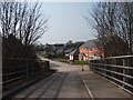
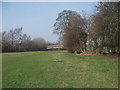
View across the accommodation bridge
The bridge rises steeply in the middle so this view slowly appears as you walk over. Image]
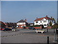
The new houses on the right include the sales "show house" of a small development hidden from view. Image]
The houses with the roof top solar panels are to "senior" bungalows on a local authority estate.
Image: © John Haynes
Taken: 24 Mar 2012
0.03 miles
4
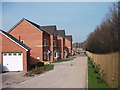
Llys Woodbank Rhiwabon
These new houses have been squeezed into a space between the A483 and an established estate. The house attached to the garage on the left is the sales "show house".
Image: © John Haynes
Taken: 24 Mar 2012
0.08 miles
5
Footpath towards the accommodation bridge
The A483 divides this small area from the main part of Rhiwabon but access to Fron Goch Farm & the allotment gardens is via the accommodation bridge. Image]
Image: © John Haynes
Taken: 24 Mar 2012
0.09 miles
6
Houses & shops on Rhiwabon high street
The A483 used to pass through here, now it is just a busy village centre. Large house to the right, shops to left (looking very like houses) and the large terrace houses beyond would have been "best end" housing pre-1939.
Image: © John Haynes
Taken: 24 Mar 2012
0.11 miles
7
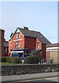
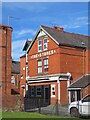
The Stores, Ruabon
On Henry Street, Ruabon
Image: © Eirian Evans
Taken: 19 Mar 2008
0.11 miles
8
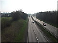
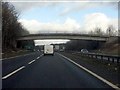
A483 at Rhiwabon
Road heading south and dividing right towards Shrewsbury joining the A5 at Halton having crossed the Afon Dyfrdwy. Image]
Left is A539 to Llangollen where it joins the A5 to Holyhead.
Image: © John Haynes
Taken: 24 Mar 2012
0.13 miles
9
The Gate House, Ruabon
The Gate House stands next to Ruabon Gates, the Ruabon entrance to the Wynnstay Park.Image
Image: © Eirian Evans
Taken: 26 Sep 2007
0.13 miles
10
Rhiwabon
Nowhere is the brilliant red Ruabon brick better shown off than in its home village on a bright early spring morning.
Image: © Mike Parker
Taken: 1 Mar 2022
0.13 miles