IMAGES TAKEN NEAR TO
Chirk, WREXHAM, LL14 5LN
Introduction
This page details the photographs taken nearby to LL14 5LN by members of the Geograph project.
The Geograph project started in 2005 with the aim of publishing, organising and preserving representative images for every square kilometre of Great Britain, Ireland and the Isle of Man.

There are currently over 7.5m images from over14,400 individuals and you can help contribute to the project by visiting https://www.geograph.org.uk
Image Map (Loading...)


Getting Data...Please wait
Leaflet Map data © OpenStreetMap
Images are licensed for reuse under creativecommons.org/licenses/by-sa/2.0
Notes
- Clicking on the map will re-center to the selected point.
- The higher the marker number, the further away the image location is from the centre of the postcode.
Image Listing (5 Images Found)
Images are licensed for reuse under creativecommons.org/licenses/by-sa/2.0
Image
Details
Distance
1
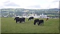
Cattle above Chirk
The Kronspan factory forms the background, destination for a lot of Southern Scotland's Sitka spruce.
Image: © Richard Webb
Taken: 15 Aug 2019
0.17 miles
2
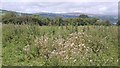
Thistles above Chirk
A somewhat overgrown hilltop field.
Image: © Richard Webb
Taken: 15 Aug 2019
0.19 miles
3
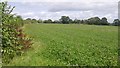
Hilltop field near Chirk
Between the town and A5.
Image: © Richard Webb
Taken: 15 Aug 2019
0.21 miles
4
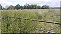
Hard standing, Ley Farm
A field of thistles with hardcore beneath. Between a yellow road and the A5 Chirk bypass.
Image: © Richard Webb
Taken: 15 Aug 2019
0.21 miles
5
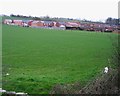
Housing Estate in Chirk
A modern housing estate in Chirk viewed from the minor road near Lodge Farm
Image: © John S Turner
Taken: 8 Mar 2007
0.25 miles