
IMAGES TAKEN NEAR TO
Spring Road, WREXHAM, LL14 4DY
Introduction
This page details the photographs taken nearby to Spring Road, LL14 4DY by members of the Geograph project.
The Geograph project started in 2005 with the aim of publishing, organising and preserving representative images for every square kilometre of Great Britain, Ireland and the Isle of Man.

There are currently over 7.5m images from over14,400 individuals and you can help contribute to the project by visiting https://www.geograph.org.uk
Image Map
Images are licensed for reuse under creativecommons.org/licenses/by-sa/2.0
Notes
- Clicking on the map will re-center to the selected point.
- The higher the marker number, the further away the image location is from the centre of the postcode.
Image Listing (54 Images Found)
Images are licensed for reuse under creativecommons.org/licenses/by-sa/2.0
Image
Details
Distance

2
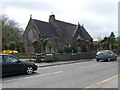
Holy Trinity Church, Esclusham
The parish of Esclusham was formed in 1879 from the townships of Erddig, Esclusham Below, and a portion of Esclusham Above. The foundation stone of the church was laid on 24 October 1876, and it was consecrated on 12 September 1877, in the name of the Holy Trinity.
Image: © Eirian Evans
Taken: 7 Apr 2011
0.07 miles
3
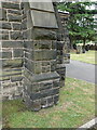
North west corner of Holy Trinity church, Rhostyllen
The buttress at the north west corner of Holy Trinity church has an Ordnance Survey benchmark Image
Image: © John S Turner
Taken: 26 Jun 2023
0.07 miles
4
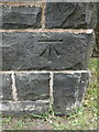
Benchmark on Holy Trinity church, Rhostyllen
Ordnance Survey benchmark on the north west corner buttress of Holy Trinity church alongside Wrexham Road, Rhostyllen. Levelled at 100.279m above Newlyn Datum, verified 1960. For a wider view see Image
Benchmark database https://www.bench-marks.org.uk/bm195750
Image: © John S Turner
Taken: 26 Jun 2023
0.07 miles
5
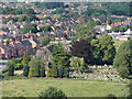
Holy Trinity Church and Churchyard
Viewed from the top of Bersham Tip.
Image: © Ian Paterson
Taken: 28 Jun 2011
0.07 miles
6
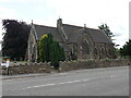
Holy Trinity church, Wrexham Road, Rhostyllen
The foundation stone of the Holy Trinity church was laid on the 24th October 1876, and it was consecrated on the 12th September 1877.
Image: © John S Turner
Taken: 26 Jun 2023
0.07 miles
8

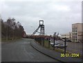
XGAS offices, Rhostyllen, and a bench mark
Formerly Colliery Garage, Rhostyllen, the XGAS offices have an Ordnance Survey bench mark on the corner nearest the camera - Image
Image: © John S Turner
Taken: 30 Sep 2018
0.09 miles
9
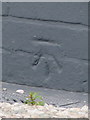
Bench mark on XGAS offices, Rhostyllen
This Ordnance Survey bench mark is on the corner of the old buildings that are now the XGAS offices in Rhostyllen. The mark is visible from the road. See also Image
Image: © John S Turner
Taken: 30 Sep 2018
0.09 miles
10
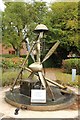
Detail from Rhostyllen war memorial
Two identical memorials, one in English the other in Welsh - Image]
Image: © Richard Hoare
Taken: 8 Oct 2018
0.10 miles