IMAGES TAKEN NEAR TO
Penllwyn, WREXHAM, LL14 1YG
Introduction
This page details the photographs taken nearby to Penllwyn, LL14 1YG by members of the Geograph project.
The Geograph project started in 2005 with the aim of publishing, organising and preserving representative images for every square kilometre of Great Britain, Ireland and the Isle of Man.

There are currently over 7.5m images from over14,400 individuals and you can help contribute to the project by visiting https://www.geograph.org.uk
Image Map (Loading...)


Getting Data...Please wait
Leaflet Map data © OpenStreetMap
Images are licensed for reuse under creativecommons.org/licenses/by-sa/2.0
Notes
- Clicking on the map will re-center to the selected point.
- The higher the marker number, the further away the image location is from the centre of the postcode.
Image Listing (9 Images Found)
Images are licensed for reuse under creativecommons.org/licenses/by-sa/2.0
Image
Details
Distance
1
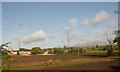
Power lines marching away from railway
Just north of Johnstown
Image: © John Firth
Taken: 10 May 2014
0.14 miles
2
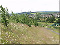
Johnstown from the Hafod colliery bing
Johnstown across the Chester to Shrewsbury railway line pictured from the bing produced from Hafod colliery and the nearby Ruabon tile works.
Image: © John Haynes
Taken: 29 Jun 2002
0.14 miles
3
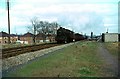
The site of Johnstown and Hafod Station, 1967
Stanier 8F 2-8-0 48063 heads south on a general freight. The sidings on the right were the exchange sidings for Hafod Colliery. The station closed in 1960 and had been completely removed by 1967
Image: © Alan Murray-Rust
Taken: 4 Mar 1967
0.15 miles
4
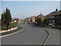
Houses on Rhodfa Linley
This street of houses backs on to the Shrewsbury to Chester railway.
Image: © John Haynes
Taken: 24 Mar 2012
0.16 miles
5
Infill modern houses
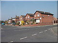
The used to be two community shops on this site, they were replaced by these houses in 2002.
Image: © John Haynes
Taken: 24 Mar 2012
0.18 miles
6
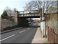
Bridge carrying the Shrewsbury to Chester railway
Through the bridge are houses on Bangor Road, the railway forms the boundary between housing and industry.
Image: © John Haynes
Taken: 24 Mar 2012
0.20 miles
7
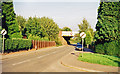
Approaching site of former Johnstown & Hafod station, 1999
View east on Bangor Road towards Hafod. The station had been on the right, but closed 12/9/60; ex-GWR Shrewsbury - Chester main line. (Cf. Image).
Image: © Ben Brooksbank
Taken: 6 Sep 1999
0.22 miles
8
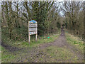
Sign at the Aberderfyn Nature Reserve
Entrance to the nature reserve, which is basically land allowed to grow up as it used to be the Hafod-y-Bwch colliery.
Image: © TCExplorer
Taken: 4 Mar 2024
0.24 miles
9
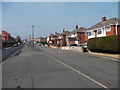
Houses on Bangor Road
Much modified 1930's semis, the front hall and the kitchen was very small in these houses (reproduced all over the UK) and many variations of retro fitted doorways are in evidence here.
Image: © John Haynes
Taken: 24 Mar 2012
0.25 miles