IMAGES TAKEN NEAR TO
North Road, WREXHAM, LL14 1LE
Introduction
This page details the photographs taken nearby to North Road, LL14 1LE by members of the Geograph project.
The Geograph project started in 2005 with the aim of publishing, organising and preserving representative images for every square kilometre of Great Britain, Ireland and the Isle of Man.

There are currently over 7.5m images from over14,400 individuals and you can help contribute to the project by visiting https://www.geograph.org.uk
Image Map
Images are licensed for reuse under creativecommons.org/licenses/by-sa/2.0
Notes
- Clicking on the map will re-center to the selected point.
- The higher the marker number, the further away the image location is from the centre of the postcode.
Image Listing (9 Images Found)
Images are licensed for reuse under creativecommons.org/licenses/by-sa/2.0
Image
Details
Distance
1
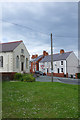
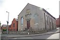
Chapel Street, Ponciau
This is the top of Chapel Street where it meets Fennant Road and Johnson Street. On the left is Capel Bethel which was built in 1859.
Image: © Stephen McKay
Taken: 30 May 2019
0.16 miles
2
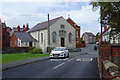
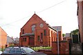
Chapel Street, Ponciau
Chapel Street has several chapels along its length including Capel Bethel seen here which dates from 1859. In 1903 it was replaced by the new chapel to the rear and the old building was then used as a Sunday school.
Image: © Stephen McKay
Taken: 30 May 2019
0.16 miles
3
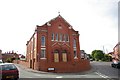
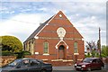
Seion, Capel y Bedyddwyr, Ponciau
Zion is an ancient Hebrew term which can mean Israel, Jerusalem or Mount Zion in Jerusalem.
This chapel was built in 1900 A.D.
Bedyddwyr means 'Baptist'.
Image: © Peter Craine
Taken: 3 Jun 2008
0.17 miles
4
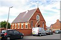
Capel Salem, Ponciau
Salem is believed to be the original place name for "Jerusalem".
Denomination: Congregationalist.
Image: © Peter Craine
Taken: 3 Jun 2008
0.17 miles
5
Side building to Bethel chapel, Ponciau
This appears to be the original Bethel chapel - see Image
I think it is dated 1850.
Image: © Peter Craine
Taken: 3 Jun 2008
0.18 miles
6
Tabernacl y Bedyddwyr, Ponciau
Tabernacle is a Hebrew word for a dwelling place for "the divine presence" i.e. God.
This building is dated 1883. Bedyddwyr means 'Baptist'
Image: © Peter Craine
Taken: 3 Jun 2008
0.19 miles
7
Bethel, Eglwys Bresbyteraidd, Ponciau
According to http://www.genuki.org.uk/big/wal/DEN/Rhosllanerchrugog/ , the denomination for this church is Calvinistic Methodist. It is dated 1903.
Image: © Peter Craine
Taken: 3 Jun 2008
0.19 miles
8
Ysgol y Grango at Rhosllannerchrugog
The local senior school at Rhosllannerchrugog.
Image: © John Haynes
Taken: 17 Sep 2005
0.21 miles
9
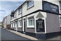
The Colliers Arms, Ponciau
This pub may be somewhat off the beaten track but it was the Campaign for Real Ale's Clwyd branch pub of the year in 2016. In their words it is to be cherished. The name reflects the fact that this was once a mining village.
Image: © Stephen McKay
Taken: 30 May 2019
0.21 miles