IMAGES TAKEN NEAR TO
Manley Road, WREXHAM, LL13 8HE
Introduction
This page details the photographs taken nearby to Manley Road, LL13 8HE by members of the Geograph project.
The Geograph project started in 2005 with the aim of publishing, organising and preserving representative images for every square kilometre of Great Britain, Ireland and the Isle of Man.

There are currently over 7.5m images from over14,400 individuals and you can help contribute to the project by visiting https://www.geograph.org.uk
Image Map
Images are licensed for reuse under creativecommons.org/licenses/by-sa/2.0
Notes
- Clicking on the map will re-center to the selected point.
- The higher the marker number, the further away the image location is from the centre of the postcode.
Image Listing (44 Images Found)
Images are licensed for reuse under creativecommons.org/licenses/by-sa/2.0
Image
Details
Distance
1
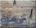
Waterless Water Feature.
The combination of the six cypress-type trees and local slate slabs seem vaguely reminiscent of a mediterranean cemetery.
Image: © Geoff Evans
Taken: 4 Feb 2009
0.11 miles
2
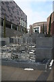
Waterless Water Feature
This new feature of Wrexham's new shopping mall, whilst less than five weeks old seems to have run out of water, making the local material of slate reminiscent of the slate gravestones of Snowdonia.
Image: © Geoff Evans
Taken: 4 Feb 2009
0.11 miles
3
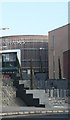
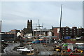
Eagles Meadows development
Following the demise of A.S.D.A, and the car park, this new development consisting of Shops, Cinema, Bowling Alley Etc., is quickly taking Shape. This photo taken from the " Flyover" before that disappears, is of the steelwork forming what will be M & S, the Odeon & Debenhams.
Image: © Geoff Evans
Taken: 13 Feb 2007
0.11 miles
4
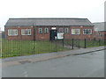
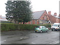
St Peter's Hall
These are Caia Park Council Rooms. St Peter's Church is just visible on the right, but it is now closed.
Image: © Eirian Evans
Taken: 9 Feb 2012
0.12 miles
5
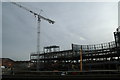
Eagles Meadows
More steel work taking shape on the site, just below the Wynnstay Hotel, which will ultimately block the view of St.Giles from the Smithfield road area.
Image: © Geoff Evans
Taken: 13 Feb 2007
0.12 miles
6
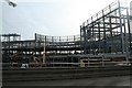
Eagles Meadows Development
The site of the new Marks & Spencer shop and Odeon Cinema from the Asda "flyover".
Image: © Geoff Evans
Taken: 13 Feb 2007
0.12 miles
7
Ordnance Survey Cut Mark
This OS cut mark can be found on the wall of No25 Hightown Road. It marks a point 73.289m above mean sea level.
Image: © Adrian Dust
Taken: 22 Oct 2021
0.13 miles
8
Wrexham Revival Fire Church
Pentecostal church on Bernard Road, Wrexham.
Image: © Eirian Evans
Taken: 9 Feb 2012
0.14 miles
9
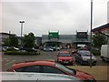
Car park and retail stores in Wrexham
Image: © Darrin Antrobus
Taken: 10 Jun 2013
0.15 miles
10
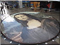
The 'Worlds largest Mona Lisa'
At least that is the claim for this artwork in the Eagles Meadow Shopping Centre. The statistics are: 17.5 metres in diameter, 240 square metres, 82 segments each 1 metre by 3.5 metres, 86 litres of paint, hand painted, 972 hours of painting by 246 people. Painted by Lead Artist - Katy Webster, Artists - Julie Davies, Lucy Howarth, Pam Webster Haulfan Centre, Victoria Primary School. Quite an amazing piece of work when viewed from the first floor balcony. (It was not possible to photograph it 'head-on' because of the reflections on this very wet day).
Image: © John S Turner
Taken: 20 Nov 2009
0.16 miles