IMAGES TAKEN NEAR TO
Benjamin Road, WREXHAM, LL13 8EG
Introduction
This page details the photographs taken nearby to Benjamin Road, LL13 8EG by members of the Geograph project.
The Geograph project started in 2005 with the aim of publishing, organising and preserving representative images for every square kilometre of Great Britain, Ireland and the Isle of Man.

There are currently over 7.5m images from over14,400 individuals and you can help contribute to the project by visiting https://www.geograph.org.uk
Image Map
Images are licensed for reuse under creativecommons.org/licenses/by-sa/2.0
Notes
- Clicking on the map will re-center to the selected point.
- The higher the marker number, the further away the image location is from the centre of the postcode.
Image Listing (10 Images Found)
Images are licensed for reuse under creativecommons.org/licenses/by-sa/2.0
Image
Details
Distance
1
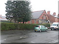
Wrexham Revival Fire Church
Pentecostal church on Bernard Road, Wrexham.
Image: © Eirian Evans
Taken: 9 Feb 2012
0.04 miles
2
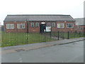
St Peter's Hall
These are Caia Park Council Rooms. St Peter's Church is just visible on the right, but it is now closed.
Image: © Eirian Evans
Taken: 9 Feb 2012
0.07 miles
4
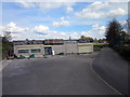
Building Renovation at the Queensway Sports Complex, Wrexham
A building, possibly once the changing rooms or the entrance to the playing fields, being renovated.
Image: © Jeff Buck
Taken: 13 Apr 2016
0.14 miles
5
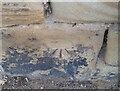
Ordnance Survey Cut Mark
This OS cut mark can be found on the wall of No25 Hightown Road. It marks a point 73.289m above mean sea level.
Image: © Adrian Dust
Taken: 22 Oct 2021
0.19 miles
6
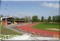
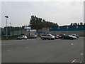
Queensway Stadium, Wrecsam
Athletics stadium tucked away within the Caia Park area of Wrecsam. http://www.wrexham.gov.uk/english/leisure_tourism/queensway/queensway_index.htm#facilities
Image: © John Haynes
Taken: 29 Apr 2006
0.21 miles
7
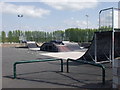
Skate Park at Caia Park, Wrecsam
Great technical park this.
Image: © John Haynes
Taken: 29 Apr 2006
0.21 miles
8
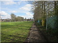
Path through The Dunks, Wrexham
A public footpath through an area of Wrexham called The Dunks. This path lies between the Queensway Sports Complex (on the right) and playing fields.
Image: © Jeff Buck
Taken: 13 Apr 2016
0.22 miles
9
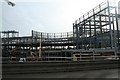
Eagles Meadows Development
The site of the new Marks & Spencer shop and Odeon Cinema from the Asda "flyover".
Image: © Geoff Evans
Taken: 13 Feb 2007
0.25 miles
10
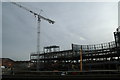
Eagles Meadows development
Following the demise of A.S.D.A, and the car park, this new development consisting of Shops, Cinema, Bowling Alley Etc., is quickly taking Shape. This photo taken from the " Flyover" before that disappears, is of the steelwork forming what will be M & S, the Odeon & Debenhams.
Image: © Geoff Evans
Taken: 13 Feb 2007
0.25 miles