IMAGES TAKEN NEAR TO
Percy Road, WREXHAM, LL13 7EB
Introduction
This page details the photographs taken nearby to Percy Road, LL13 7EB by members of the Geograph project.
The Geograph project started in 2005 with the aim of publishing, organising and preserving representative images for every square kilometre of Great Britain, Ireland and the Isle of Man.

There are currently over 7.5m images from over14,400 individuals and you can help contribute to the project by visiting https://www.geograph.org.uk
Image Map
Images are licensed for reuse under creativecommons.org/licenses/by-sa/2.0
Notes
- Clicking on the map will re-center to the selected point.
- The higher the marker number, the further away the image location is from the centre of the postcode.
Image Listing (15 Images Found)
Images are licensed for reuse under creativecommons.org/licenses/by-sa/2.0
Image
Details
Distance
1
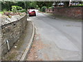
Sontley Road from its Belgrave Road junction
Looking south along Sontley Road from its junction with Belgrave Road.
Image: © John S Turner
Taken: 21 Jul 2014
0.11 miles
2
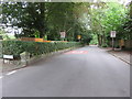
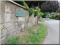
Erddig Road and Sontley Road
The near part of this road is Erddig Road, with an Ordnance Survey bench mark this side of the gas(?) pipe - Image, then it continues as Sontley Road towards the red car. Erddig Road itself turns sharp right from here and then continues at an angle.
Image: © John S Turner
Taken: 21 Jul 2014
0.16 miles
3
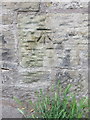
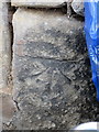
Bench mark in Erddig Road, Wrexham
This Ordnance Survey bench mark is close to the Erddig Road junction with Trevor Road and Fairy Road. See also Image
Image: © John S Turner
Taken: 21 Jul 2014
0.17 miles
4
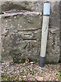
Bench mark outside #81 Erddig Road
This Ordnance Survey bench mark is on the wall of #81 Erddig Road, beyond which the road becomes Sontley Road - see: Image Erddig Road itself turns sharp right here.
Image: © John S Turner
Taken: 21 Jul 2014
0.17 miles
5
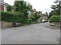
Erddig Road and a bench mark
Looking south west along Erddig Road from its junction with Trevor Road and Fairy Road. There is an Ordnance Survey bench mark on the stone wall to the left: see Image
Image: © John S Turner
Taken: 21 Jul 2014
0.17 miles
6
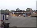
Changing times, school being up-dated
School being refurbished.
Image: © John Haynes
Taken: 15 Oct 2005
0.19 miles
7
Bench mark outside #59 Erddig Road
This weathered bench mark is on the roadside wall fronting #59 Erddig Road. See also Image
Image: © John S Turner
Taken: 21 Jul 2014
0.20 miles
8
Erddig Road junction with Wellington Road and Fairfield Street
Looking across the junction of Erddig Road, straight ahead, with Wellington Road to the right. Fairfield Street also joins from the left. Across the road, and behind the wheelie bin for #59 Erddig Road, there is a weathered Ordnance Survey bench mark - Image
Image: © John S Turner
Taken: 21 Jul 2014
0.20 miles
9
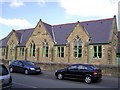
Infants School, Wrexham
It is on Poplar Road
Image: © Kenneth Allen
Taken: 29 Apr 2006
0.20 miles
10
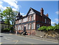
Former Green Dragon Hotel, Wrexham
On Salop Road.
Image: © JThomas
Taken: 4 May 2019
0.21 miles