IMAGES TAKEN NEAR TO
Kiln Lane, WREXHAM, LL12 9PL
Introduction
This page details the photographs taken nearby to Kiln Lane, LL12 9PL by members of the Geograph project.
The Geograph project started in 2005 with the aim of publishing, organising and preserving representative images for every square kilometre of Great Britain, Ireland and the Isle of Man.

There are currently over 7.5m images from over14,400 individuals and you can help contribute to the project by visiting https://www.geograph.org.uk
Image Map
Images are licensed for reuse under creativecommons.org/licenses/by-sa/2.0
Notes
- Clicking on the map will re-center to the selected point.
- The higher the marker number, the further away the image location is from the centre of the postcode.
Image Listing (68 Images Found)
Images are licensed for reuse under creativecommons.org/licenses/by-sa/2.0
Image
Details
Distance
4
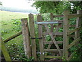
Stile on the footpath on Wat's Dyke in Hope
This stile sits on the footpath that runs along this section of the dyke, between horse paddocks and the back gardens of adjacent homes.
Image: © Jeremy Bolwell
Taken: 16 May 2011
0.11 miles
5

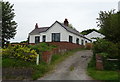
Ysgol Estyn, Hope
The local county primary school on Howarden Road
Image: © Eirian Evans
Taken: 17 Feb 2012
0.15 miles
6
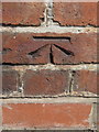
Bench mark in front of Ysgol Estyn, Hawarden Road, Hope
This Ordnance Survey bench mark is on the roadside wall of Ysgol Estyn, just south of the pedestrian gate - Image
Image: © John S Turner
Taken: 24 May 2017
0.15 miles
7
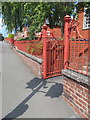
Pedestrian entrance to Ysgol Estyn, Hawarden Road, Hope
There is an Ordnance Survey bench mark cut into the brickwork just this side of the gateway - Image
Image: © John S Turner
Taken: 24 May 2017
0.15 miles
8
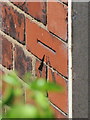
Bench mark on #28 Hawarden Road, Hope
This Ordnance Survey cut bench mark is on the south east corner of #28 Hawarden Road, a private house. The mark is just visible from the pavement.
Image: © John S Turner
Taken: 24 May 2017
0.17 miles
9
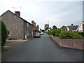
Lane towards the medieval church in Hope
The footpath follows this old lane, now a residential road with bungalows each side, towards the church.
Image: © Jeremy Bolwell
Taken: 16 May 2011
0.17 miles
10
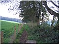
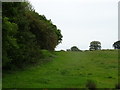
Wat's Dyke
It's not obvious, but this footpath runs along the top of the ancient boundary known as Wat's Dyke. On the other side of the trees on the right, there is a significant drop to the field below.
Image: © John S Turner
Taken: 6 Nov 2006
0.17 miles