IMAGES TAKEN NEAR TO
Stancliffe Avenue, WREXHAM, LL12 8LP
Introduction
This page details the photographs taken nearby to Stancliffe Avenue, LL12 8LP by members of the Geograph project.
The Geograph project started in 2005 with the aim of publishing, organising and preserving representative images for every square kilometre of Great Britain, Ireland and the Isle of Man.

There are currently over 7.5m images from over14,400 individuals and you can help contribute to the project by visiting https://www.geograph.org.uk
Image Map
Images are licensed for reuse under creativecommons.org/licenses/by-sa/2.0
Notes
- Clicking on the map will re-center to the selected point.
- The higher the marker number, the further away the image location is from the centre of the postcode.
Image Listing (9 Images Found)
Images are licensed for reuse under creativecommons.org/licenses/by-sa/2.0
Image
Details
Distance
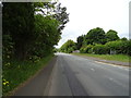
2
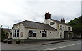
The Red Lion, Marford
On Marford Hill (B5445).
Image: © JThomas
Taken: 25 May 2019
0.09 miles
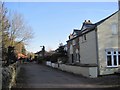
3
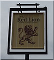
Sign for the Red Lion, Marford
See Image] for context.
Image: © JThomas
Taken: 25 May 2019
0.09 miles
4
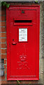
Elizabeth II postbox on Marford Hill, Marford
Postbox No. LL12 55.
Image: © JThomas
Taken: 25 May 2019
0.10 miles
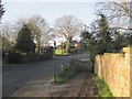
6
Footpath sign, Turnpike Lane Pant
The path leads to Marford village and the B5445.
Image: © Jim Barton
Taken: 15 Feb 2019
0.17 miles
7
Footpath from Pant Lane
The path turns down into Marford Wood towards the railway line and Marford village.
Image: © Jim Barton
Taken: 15 Feb 2019
0.17 miles
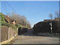
8
Turnpike Lane, Pant
A short access road for houses to the east of Marford Wood.
Image: © Jim Barton
Taken: 15 Feb 2019
0.19 miles
9
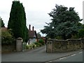
Horsley Lodge
Horsley Lodge is the entrance to the old Horsley Hall which is now derelict and overgrown.
Image: © Ian Formstone
Taken: 15 Aug 2006
0.23 miles