IMAGES TAKEN NEAR TO
The Laurels, WREXHAM, LL12 7NW
Introduction
This page details the photographs taken nearby to The Laurels, LL12 7NW by members of the Geograph project.
The Geograph project started in 2005 with the aim of publishing, organising and preserving representative images for every square kilometre of Great Britain, Ireland and the Isle of Man.

There are currently over 7.5m images from over14,400 individuals and you can help contribute to the project by visiting https://www.geograph.org.uk
Image Map (Loading...)


Getting Data...Please wait
Leaflet Map data © OpenStreetMap
Images are licensed for reuse under creativecommons.org/licenses/by-sa/2.0
Notes
- Clicking on the map will re-center to the selected point.
- The higher the marker number, the further away the image location is from the centre of the postcode.
Image Listing (5 Images Found)
Images are licensed for reuse under creativecommons.org/licenses/by-sa/2.0
Image
Details
Distance
1
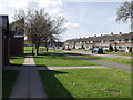
Houses on Herbert Jennings Avenue
Houses overlooking open space at Rhosnesni, Wrecsam. Herbert Jennings was a previous mayor ( in 1953 ) of Wrecsam. http://www.wrexham.gov.uk/english/council/mayoralty/mayoralty_list.htm
Image: © John Haynes
Taken: 29 Apr 2006
0.14 miles
2
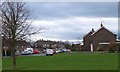
Herbert Jennings Avenue from Acton Park, Wrexham
Housing on the southern side of the park, formerly land of the Acton Hall estate.
Image: © Jim Barton
Taken: 25 Dec 2011
0.17 miles
3
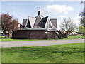
St John's Church, Rhosnesni, Wrecsam
Ultra modern church standing on the edge of a great open space, once part of Acton Park.
Image: © John Haynes
Taken: 29 Apr 2006
0.21 miles
4
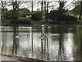
The Lake, Acton Park, Wrecsam
The southern half of the lake, swans busy organising the nesting site, geese hanging around. Well fed, no aggressive begging here.
Image: © John Haynes
Taken: 29 Apr 2006
0.21 miles
5
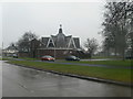
St John's Church, Rhosesni
At the junction of Borras Road and Herbert Jennings Avenue
Image: © Eirian Evans
Taken: 9 Feb 2012
0.23 miles