IMAGES TAKEN NEAR TO
Ruthin Road, WREXHAM, LL11 5UT
Introduction
This page details the photographs taken nearby to Ruthin Road, LL11 5UT by members of the Geograph project.
The Geograph project started in 2005 with the aim of publishing, organising and preserving representative images for every square kilometre of Great Britain, Ireland and the Isle of Man.

There are currently over 7.5m images from over14,400 individuals and you can help contribute to the project by visiting https://www.geograph.org.uk
Image Map
Images are licensed for reuse under creativecommons.org/licenses/by-sa/2.0
Notes
- Clicking on the map will re-center to the selected point.
- The higher the marker number, the further away the image location is from the centre of the postcode.
Image Listing (23 Images Found)
Images are licensed for reuse under creativecommons.org/licenses/by-sa/2.0
Image
Details
Distance
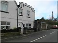
1
Capel Nebo, Bwlchgwyn
Now converted into a house, this chapel was built in 1852 for the Independents.
Image: © Eirian Evans
Taken: 7 Apr 2011
0.02 miles
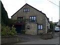
3
House on Ruthin Road, Bwlchgwyn
With striking roof detail
Image: © Eirian Evans
Taken: 7 Apr 2011
0.06 miles
5
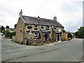
The King's Head, Bwlchgwyn
Pub on the A525 main road through Bwlchgwyn, still proclaimed, at the time of submission of this photograph, on the entrance to the village to be the highest village in Wales. The Ordnance Survey showed that it is only the third highest village behind Trefil and Garn yr Erw.
Image: © G Laird
Taken: 18 Jul 2018
0.09 miles
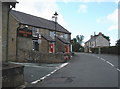
6
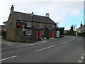
The Kings Head Inn, Bwlchgwyn
Standing on the crossroads of Ruthin Road, Fronheulog Hill and Brymbo Road. The last remaining open pub in Bwlchgwyn.
Image: © Eirian Evans
Taken: 7 Apr 2011
0.09 miles
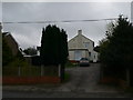
7
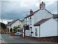
Houses on the A525
As the road heads off towards Four Crosses the houses of Bwlchgwyn begin to thin out.
Image: © John Haynes
Taken: 21 Jun 2016
0.10 miles
8

The Cenotaph
The Bwlchgwyn Cenotaph on a bleak winter's day
Image: © Bob Shires
Taken: 9 Feb 2007
0.11 miles
9
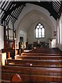
Christ Church, Bwlchgwyn
A view of the interior of the church.
Image: © Eirian Evans
Taken: 6 Nov 2007
0.12 miles
10
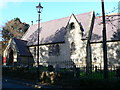
Bwlchgwyn Church
A combined school and chapel of ease was built in 1867. It was later converted to a church by adding a chancel, vestry and porch, and was consecrated as Christ Church on 1 October 1879.
Image: © Eirian Evans
Taken: 6 Nov 2007
0.12 miles