IMAGES TAKEN NEAR TO
Heol Pedr, WREXHAM, LL11 4EY
Introduction
This page details the photographs taken nearby to Heol Pedr, LL11 4EY by members of the Geograph project.
The Geograph project started in 2005 with the aim of publishing, organising and preserving representative images for every square kilometre of Great Britain, Ireland and the Isle of Man.

There are currently over 7.5m images from over14,400 individuals and you can help contribute to the project by visiting https://www.geograph.org.uk
Image Map
Images are licensed for reuse under creativecommons.org/licenses/by-sa/2.0
Notes
- Clicking on the map will re-center to the selected point.
- The higher the marker number, the further away the image location is from the centre of the postcode.
Image Listing (13 Images Found)
Images are licensed for reuse under creativecommons.org/licenses/by-sa/2.0
Image
Details
Distance
1
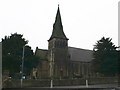
Holy Trinity Church, Gwersyllt
The foundation stone of the church was laid on 13 July 1850 for the new parish of Gwersyllt, created from parts of the townships of Gwersyllt (formerly in the parish of Gresford), and Stansty (formerly in the parish of Wrexham).
The foundation stone of the church was laid on 13 July 1850, and the church was consecrated in the name of the Holy Trinity, on 25 July 1851.
Image: © Eirian Evans
Taken: 27 Nov 2007
0.12 miles
2
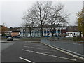
Bryn Alyn School, Gwersyllt
Ysgol Bryn Alyn is one of the major secondary schools in Wrexham. Its catchment area includes its local primary schools within Gwersyllt, but also other villages such as near by Summerhill and those further afield such as: Tanyfron, Bradley, Brymbo, Brynteg and Southsea.
Image: © Eirian Evans
Taken: 27 Nov 2007
0.13 miles
3
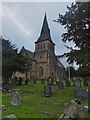
Holy Trinity Church, Gwersyllt (1)
The foundation stone of the church was laid on 13 July 1850, and the church was consecrated in the name of the Holy Trinity, on 25 July 1851.
A Church in Wales.
Image: © Richard Hoare
Taken: 30 Oct 2013
0.16 miles
4
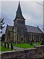
Holy Trinity Church, Gwersyllt (2)
The foundation stone of the church was laid on 13 July 1850, and the church was consecrated in the name of the Holy Trinity, on 25 July 1851.
A Church in Wales.
Image: © Richard Hoare
Taken: 30 Oct 2013
0.16 miles
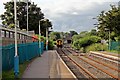
5
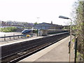
Gwersyllt Station
The station is on the Wrecsam to Birkenhead line.
http://www.arrivatrainswales.co.uk/en/travel/station_detail.php?subnavID=75&categoryID=336
Image: © John Haynes
Taken: 29 Apr 2006
0.23 miles
7
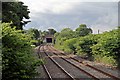
Footbridge north of Gwersyllt railway station
Beyond the footbridge is a short tunnel, where the track goes beneath the A541 Mold Road.
Image: © El Pollock
Taken: 11 Jun 2014
0.24 miles
8
Gwersyllt station
View northward, towards Hawarden Bridge, Chester and Bidston: ex-GCR (Wrexham & Connah's Quay section), Seacombe (until 4/1/60) - Bidston - Hawarden Bridge - Wrexham Central line, also (until 9/9/68) Chester Northgate - Hawarden Bridge. This is a remarkable line, a penetration of the LNER (ex-GCR) into Wales, which remains active as a 'commuter' line and even as a freight outlet from Merseyside (Birkenhead).
Image: © Ben Brooksbank
Taken: 5 Aug 1995
0.24 miles

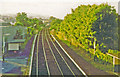
10
Departing train, Gwersyllt railway station
Arriva Trains Wales unit 150284 heads away from the camera, with a service north, to Bidston.
Image: © El Pollock
Taken: 11 Jun 2014
0.25 miles