IMAGES TAKEN NEAR TO
Talwrn Road, WREXHAM, LL11 3DQ
Introduction
This page details the photographs taken nearby to Talwrn Road, LL11 3DQ by members of the Geograph project.
The Geograph project started in 2005 with the aim of publishing, organising and preserving representative images for every square kilometre of Great Britain, Ireland and the Isle of Man.

There are currently over 7.5m images from over14,400 individuals and you can help contribute to the project by visiting https://www.geograph.org.uk
Image Map
Images are licensed for reuse under creativecommons.org/licenses/by-sa/2.0
Notes
- Clicking on the map will re-center to the selected point.
- The higher the marker number, the further away the image location is from the centre of the postcode.
Image Listing (7 Images Found)
Images are licensed for reuse under creativecommons.org/licenses/by-sa/2.0
Image
Details
Distance
1
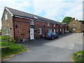
Barn conversion at Llidiart Fanny Farm
Completed conversion looks good. The surrounding buildings leave a bit to be desired.
Image]
Image: © John Haynes
Taken: 1 Jun 2016
0.01 miles
2
Unused farm buildings at Llidiart Fanny Farm
Sadly neglected and unused farm buildings.
Image: © John Haynes
Taken: 1 Jun 2016
0.02 miles
3
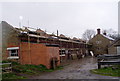
Restoration at Llidiart Farm, Talwrn
Old farm buildings being converted, near Coedpoeth.
Image: © Eirian Evans
Taken: 17 Apr 2006
0.03 miles
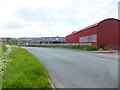
5
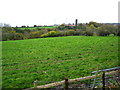
Grazing fields south of Vron Farm
The Afon Gwenfro runs through the strip of woodland and in the distance is Llidiart Fanny Farm
Image: © Maggie Cox
Taken: 15 Nov 2013
0.14 miles
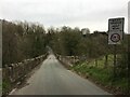
6

Footpath beside Vron Farm
In the distance is Coedpoeth
Image: © Maggie Cox
Taken: 15 Nov 2013
0.19 miles
7
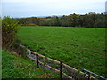
Grazing fields east of Vron Farm
The Afon Gwenfro runs through the strip of woodland. In the distance are views across the Cheshire Plain
Image: © Maggie Cox
Taken: 15 Nov 2013
0.23 miles