IMAGES TAKEN NEAR TO
Mayfield Court, WREXHAM, LL11 2TN
Introduction
This page details the photographs taken nearby to Mayfield Court, LL11 2TN by members of the Geograph project.
The Geograph project started in 2005 with the aim of publishing, organising and preserving representative images for every square kilometre of Great Britain, Ireland and the Isle of Man.

There are currently over 7.5m images from over14,400 individuals and you can help contribute to the project by visiting https://www.geograph.org.uk
Image Map
Images are licensed for reuse under creativecommons.org/licenses/by-sa/2.0
Notes
- Clicking on the map will re-center to the selected point.
- The higher the marker number, the further away the image location is from the centre of the postcode.
Image Listing (10 Images Found)
Images are licensed for reuse under creativecommons.org/licenses/by-sa/2.0
Image
Details
Distance
1
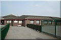
Watt's Dyke Primary School
Buildings need children to bring them to life.
Image: © Geoff Evans
Taken: 13 Apr 2007
0.07 miles
2
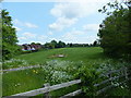
Playing fields at Garden Village
Tucked amongst the houses is a large open space.
Image: © John Haynes
Taken: 24 May 2016
0.08 miles
4
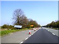
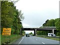
Lay-by on A483 north of Wrexham
It would be a lay-by, except that it was closed because of construction work further north
Image: © David Smith
Taken: 23 Apr 2015
0.17 miles
5
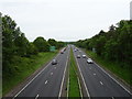
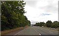
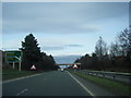
A483 towards Chester
Looking north east from the bridge on the B5425.
Image: © JThomas
Taken: 25 May 2019
0.17 miles
8
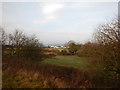
Countryside View From A483
The ancient Wat's Dyke runs through these fields. The Wat's Dyke Way follows the dyke closely.
Wikipedia : https://en.wikipedia.org/wiki/Wat's_Dyke
Trail: https://www.ldwa.org.uk/ldp/members/show_path.php?path_name=Wat%27s+Dyke+Way+Heritage+Trail
Image: © James Emmans
Taken: 14 Dec 2016
0.22 miles
10

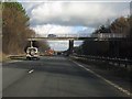
A483 near Wrexham
The A483 becomes dual carriageway between Ruabon and Chester. It passes to the west of Wrexham.
Image: © David Dixon
Taken: 15 Apr 2016
0.24 miles