IMAGES TAKEN NEAR TO
Bluebell Green, LEICESTER, LE9 9QL
Introduction
This page details the photographs taken nearby to Bluebell Green, LE9 9QL by members of the Geograph project.
The Geograph project started in 2005 with the aim of publishing, organising and preserving representative images for every square kilometre of Great Britain, Ireland and the Isle of Man.

There are currently over 7.5m images from over14,400 individuals and you can help contribute to the project by visiting https://www.geograph.org.uk
Image Map
Images are licensed for reuse under creativecommons.org/licenses/by-sa/2.0
Notes
- Clicking on the map will re-center to the selected point.
- The higher the marker number, the further away the image location is from the centre of the postcode.
Image Listing (5 Images Found)
Images are licensed for reuse under creativecommons.org/licenses/by-sa/2.0
Image
Details
Distance
1
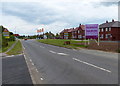
The Paddocks in Desford
New housing on the western edge of the village.
Image: © Mat Fascione
Taken: 6 Jul 2014
0.16 miles
2
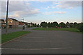
Playground on Kirkby Road, Desford
A well equipped playground on the edge of Desford. The car park services the adjacent playing field as well.
Image: © Kate Jewell
Taken: 21 Sep 2006
0.22 miles
5
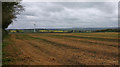
Farmland on the northern edge of Desford
The high ground on the horizon is 6 miles away at Bardon Hill, the highest point in Leicestershire at 912 feet (278 m).
Image: © Mat Fascione
Taken: 18 Apr 2020
0.25 miles