IMAGES TAKEN NEAR TO
Charnwood Road, LEICESTER, LE9 8FL
Introduction
This page details the photographs taken nearby to Charnwood Road, LE9 8FL by members of the Geograph project.
The Geograph project started in 2005 with the aim of publishing, organising and preserving representative images for every square kilometre of Great Britain, Ireland and the Isle of Man.

There are currently over 7.5m images from over14,400 individuals and you can help contribute to the project by visiting https://www.geograph.org.uk
Image Map
Images are licensed for reuse under creativecommons.org/licenses/by-sa/2.0
Notes
- Clicking on the map will re-center to the selected point.
- The higher the marker number, the further away the image location is from the centre of the postcode.
Image Listing (10 Images Found)
Images are licensed for reuse under creativecommons.org/licenses/by-sa/2.0
Image
Details
Distance
3
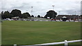
Three sports in Barwell
This is the cricket pitch with the football ground behind on the right and the indoor bowls green behind on the left.
Image: © John Welford
Taken: 4 Sep 2015
0.16 miles
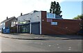
4
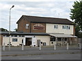
Barwell Boot & Shoe Pub
Pub away from the village centre on Moore Road.
Image: © the bitterman
Taken: 10 Jul 2010
0.16 miles
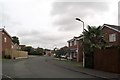
8
New Housing Built on Poor Platts charity land Kirkby Road Barwell looking towards Top Town
Image: © Chris Wilson
Taken: 15 Oct 2006
0.22 miles