IMAGES TAKEN NEAR TO
Derby Close, LEICESTER, LE9 6NF
Introduction
This page details the photographs taken nearby to Derby Close, LE9 6NF by members of the Geograph project.
The Geograph project started in 2005 with the aim of publishing, organising and preserving representative images for every square kilometre of Great Britain, Ireland and the Isle of Man.

There are currently over 7.5m images from over14,400 individuals and you can help contribute to the project by visiting https://www.geograph.org.uk
Image Map
Images are licensed for reuse under creativecommons.org/licenses/by-sa/2.0
Notes
- Clicking on the map will re-center to the selected point.
- The higher the marker number, the further away the image location is from the centre of the postcode.
Image Listing (8 Images Found)
Images are licensed for reuse under creativecommons.org/licenses/by-sa/2.0
Image
Details
Distance
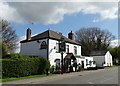
3
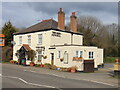
The Red Admiral, Broughton Astley
Formerly the Station Hotel
Image: © Tim Glover
Taken: 6 Mar 2022
0.16 miles
4
Broughton Astley Red Admiral
Everards pub on Station Road
Image: © the bitterman
Taken: 3 Aug 2010
0.17 miles
6
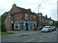
Broughton Astley Post Office
In Dunton Road
Image: © Ian Rob
Taken: 31 May 2011
0.18 miles
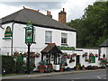
7

The Red Admiral
A roadside pub on the B581 Dunton Road
Image: © Mike W Hallett
Taken: 2 Aug 2009
0.18 miles
8
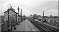
Broughton Astley Station
View NE, towards Leicester; ex-Midland Leicester - Rugby line. The line had formerly been a useful route for coal traffic to London (Willesden), but was closed, with this station, completely on 1/1/62.
Image: © Ben Brooksbank
Taken: 24 Apr 1961
0.23 miles