IMAGES TAKEN NEAR TO
Bert Cole Lane, LEICESTER, LE7 9YL
Introduction
This page details the photographs taken nearby to Bert Cole Lane, LE7 9YL by members of the Geograph project.
The Geograph project started in 2005 with the aim of publishing, organising and preserving representative images for every square kilometre of Great Britain, Ireland and the Isle of Man.

There are currently over 7.5m images from over14,400 individuals and you can help contribute to the project by visiting https://www.geograph.org.uk
Image Map
Images are licensed for reuse under creativecommons.org/licenses/by-sa/2.0
Notes
- Clicking on the map will re-center to the selected point.
- The higher the marker number, the further away the image location is from the centre of the postcode.
Image Listing (25 Images Found)
Images are licensed for reuse under creativecommons.org/licenses/by-sa/2.0
Image
Details
Distance
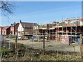
1
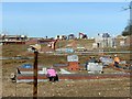
New housing development, Beeby Road, Scraptoft
Together with the Pavilion Road development, this represents a major expansion of the village of Scraptoft.
Image: © Alan Murray-Rust
Taken: 5 Apr 2018
0.02 miles
2
New housing development, Beeby Road, Scraptoft
Together with the Pavilion Road development, this represents a major expansion of the village of Scraptoft.
Image: © Alan Murray-Rust
Taken: 5 Apr 2018
0.02 miles
3
New housing development, Beeby Road, Scraptoft
Together with the Pavilion Road development, this represents a major expansion of the village of Scraptoft. The fencing is a bit more solid that the normal Heras type.
Image: © Alan Murray-Rust
Taken: 5 Apr 2018
0.07 miles
4
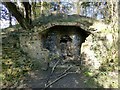
Grotto, The Mound, Scraptoft
Originally part of the grounds of Scraptoft Hall, this is a late 18th century folly. Its location close to post-war housing estates on the outskirts of Leicester has rendered it vulnerable to vandals. The roof, which was vaulted, originally came forward to the front wall. The interior was decorated with shells http://www.geograph.org.uk/photo/5734949 and coloured stone, but these have been largely broken off. Listed Grade II.
Image: © Alan Murray-Rust
Taken: 5 Apr 2018
0.07 miles
5
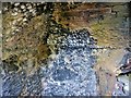
Grotto, The Mound, Scraptoft
Interior detail showing the remnants of the shell and stone decoration. See http://www.geograph.org.uk/photo/5734947 for location.
Image: © Alan Murray-Rust
Taken: 5 Apr 2018
0.07 miles
6

New housing development, Beeby Road, Scraptoft
Together with the Pavilion Road development, this represents a major expansion of the village of Scraptoft.
Image: © Alan Murray-Rust
Taken: 5 Apr 2018
0.08 miles
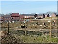
7
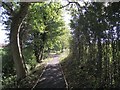
Footpath from Scraptoft to Keyham
The footpath between Beeby Road and the Mount has been surfaced; probably in conjunction with new housing developments either side of the path.
Image: © Tim Glover
Taken: 6 Sep 2018
0.08 miles
8
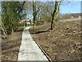
Sanitised footpath
Before the housing development on the left of the path, this was a rural path alongside a small stream, the Scraptoft Brook. The trees have been heavily thinned and the path sanitised with kerbs and hard surfacing.
Image: © Alan Murray-Rust
Taken: 5 Apr 2018
0.09 miles
9
Pavilion Road, Scraptoft
New housing, developed between 2010 and 2015.
Image: © Alan Murray-Rust
Taken: 5 Apr 2018
0.09 miles
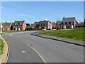
10

Goodridge housing development, Scraptoft
"A development of 3, 4 and 5-bedroom homes on the edge of Scraptoft village, close to the metropolitan hub of Leicester and the rolling Leicestershire countryside."
There are plans for further development at Scraptoft - it will soon loose its village feel.
All part of the "187,180 new homes are needed across Leicestershire" https://www.leicestermercury.co.uk/news/local-news/187180-new-homes-needed-across-2254003
Image: © Tim Heaton
Taken: 10 Jul 2019
0.11 miles