IMAGES TAKEN NEAR TO
Uppingham Road, LEICESTER, LE7 9XJ
Introduction
This page details the photographs taken nearby to Uppingham Road, LE7 9XJ by members of the Geograph project.
The Geograph project started in 2005 with the aim of publishing, organising and preserving representative images for every square kilometre of Great Britain, Ireland and the Isle of Man.

There are currently over 7.5m images from over14,400 individuals and you can help contribute to the project by visiting https://www.geograph.org.uk
Image Map
Images are licensed for reuse under creativecommons.org/licenses/by-sa/2.0
Notes
- Clicking on the map will re-center to the selected point.
- The higher the marker number, the further away the image location is from the centre of the postcode.
Image Listing (8 Images Found)
Images are licensed for reuse under creativecommons.org/licenses/by-sa/2.0
Image
Details
Distance
1
Keythorpe Grange Cottages, A47 near Tugby
Image: © Kate Jewell
Taken: 24 Jul 2006
0.08 miles
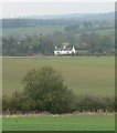
2
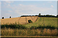
Farmland near Tugby
Looking south from the A47. The wood at the top of the hill is Ram's Head Spinney.
Image: © Kate Jewell
Taken: 24 Jul 2006
0.08 miles
3
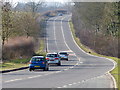
A47 heading towards Tugby
The trees on the right are Grange Spinney, shielding Keythorpe Grange from the busy A47.
Image: © Mat Fascione
Taken: 2 Mar 2013
0.08 miles
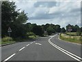
4
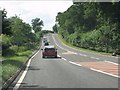
A47 - crawler lane begins at Keythorpe Grange
Image: © Peter Whatley
Taken: 28 Jul 2013
0.08 miles
5
A47 - crawler lane ends at Keythorpe Grange
Image: © Peter Whatley
Taken: 28 Jul 2013
0.19 miles
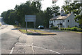
6
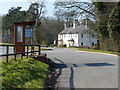
Bus shelter near Keythorpe Grange Cottages
Along the A47 near the village of East Norton.
Image: © Mat Fascione
Taken: 2 Mar 2013
0.23 miles
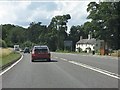
7
Cottages along the A47 Uppingham Road
As seen from Moor Lane, near East Norton in Leicestershire.
Image: © Mat Fascione
Taken: 27 Oct 2007
0.24 miles
8
A47 near East Norton
The dwelling is set on the old course of the A47. The bus shelter is diminutive, yet attractive.
Image: © Peter Whatley
Taken: 28 Jul 2013
0.25 miles