IMAGES TAKEN NEAR TO
Loddington Lane, LEICESTER, LE7 9XD
Introduction
This page details the photographs taken nearby to Loddington Lane, LE7 9XD by members of the Geograph project.
The Geograph project started in 2005 with the aim of publishing, organising and preserving representative images for every square kilometre of Great Britain, Ireland and the Isle of Man.

There are currently over 7.5m images from over14,400 individuals and you can help contribute to the project by visiting https://www.geograph.org.uk
Image Map
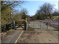
Images are licensed for reuse under creativecommons.org/licenses/by-sa/2.0
Notes
- Clicking on the map will re-center to the selected point.
- The higher the marker number, the further away the image location is from the centre of the postcode.
Image Listing (48 Images Found)
Images are licensed for reuse under creativecommons.org/licenses/by-sa/2.0
Image
Details
Distance
1
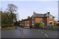
Junction of Uppingham Road and Loddington Lane, East Norton
Jasmine Cottage on the corner
Image: © Tim Heaton
Taken: 16 Dec 2019
0.01 miles
2
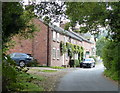
Cottages along Loddington Lane in East Norton
Image: © Mat Fascione
Taken: 21 Sep 2014
0.01 miles
3
Crossroads
The crossroads in East Norton, two legs of which are now dead ends.
Image: © Bob Harvey
Taken: 5 Oct 2020
0.01 miles
5
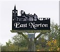
East Norton
Village sign in the centre of this Leicestershire village.
Image: © Mat Fascione
Taken: 27 Oct 2007
0.05 miles
6
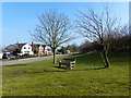
Bench in East Norton
On the corner of Moor Lane and Uppingham Road.
Image: © Mat Fascione
Taken: 2 Mar 2013
0.05 miles
7
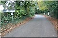
Loddington Lane enters East Norton
A small village located along the A47 in Leicestershire.
Image: © Mat Fascione
Taken: 27 Oct 2007
0.08 miles
8
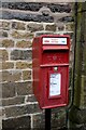
Priority Postbox
A postbox, of the style called a Lampbox, mounted on an auxiliary pillar, outside the erstwhile village post office.
Stickered up as a Priority Postbox for the despatch of postal Covid-19 tests.
Image: © Bob Harvey
Taken: 5 Oct 2020
0.08 miles
9
The old Uppingham Road in East Norton
The East Norton bypass was finally opened on October 27th 1990, this is the route of the former A47 Uppingham Road, on the eastern edge of East Norton village.
Image: © Mat Fascione
Taken: 2 Mar 2013
0.09 miles
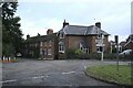
10

Former police station, East Norton
Apparently built about 1850 http://englishbuildings.blogspot.com/2018/07/east-norton-leicestershire.html
How many villages now have a police station?
Image: © Tim Heaton
Taken: 16 Dec 2019
0.09 miles