IMAGES TAKEN NEAR TO
Hamilton Lane, LEICESTER, LE7 9SB
Introduction
This page details the photographs taken nearby to Hamilton Lane, LE7 9SB by members of the Geograph project.
The Geograph project started in 2005 with the aim of publishing, organising and preserving representative images for every square kilometre of Great Britain, Ireland and the Isle of Man.

There are currently over 7.5m images from over14,400 individuals and you can help contribute to the project by visiting https://www.geograph.org.uk
Image Map
Images are licensed for reuse under creativecommons.org/licenses/by-sa/2.0
Notes
- Clicking on the map will re-center to the selected point.
- The higher the marker number, the further away the image location is from the centre of the postcode.
Image Listing (76 Images Found)
Images are licensed for reuse under creativecommons.org/licenses/by-sa/2.0
Image
Details
Distance
1
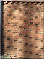
The Cottage, Hamilton Lane, Scraptoft ? detail
Only alternate headers are black bricks, giving a diagonal pattern rather than the more usual chequer. See http://www.geograph.org.uk/photo/5735099 for location.
Image: © Alan Murray-Rust
Taken: 5 Apr 2018
0.02 miles
2

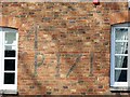
The Cottage, Hamilton Lane, Scraptoft
Dated 1710 http://www.geograph.org.uk/photo/5735102 in black brick, which is also used to create an unusual diagonal pattern in the Flemish bond brickwork http://www.geograph.org.uk/photo/5735108 . Listed Grade II.
Image: © Alan Murray-Rust
Taken: 5 Apr 2018
0.02 miles
3
The Cottage, Hamilton Lane, Scraptoft ? detail
As the windows appear to be old, it is a bit puzzling to know how the brickwork with the initials and date appeared when the house was built. See http://www.geograph.org.uk/photo/5735099 for location.
Image: © Alan Murray-Rust
Taken: 5 Apr 2018
0.02 miles
4

Nether Hall, Scraptoft
The 'W' just visible on the right hand gable is an initial which originally accompanied a date, 1709, partly lost to extensions to the building. Listed Grade II. The hall gives its name to a large council estate of Leicester City Council.
Image: © Alan Murray-Rust
Taken: 5 Apr 2018
0.03 miles
5

Main Street, Scraptoft near Leicester
Scraptoft Post Office and Stores is at the junction of Main Street with Scaptoft Rise and Hamilton Lane. Scraptoft is a village on the eastern edge of Leicester, fast being gobbled up by suburban sprawl. See http://www.british-history.ac.uk/report.asp?compid=22069 for information and history of the village.
Image: © Kate Jewell
Taken: 3 Jan 2006
0.05 miles
6

Pear Tree Stores and Rose Cottage, Scraptoft
The stores have probably been trading here for some time, although unlikely to go back quite as far as the house, which is dated 1703 http://www.geograph.org.uk/photo/5735094 . Rose Cottage, with the thatched roof, dates from around the same time, but has been substantially modernised. Both buildings are Listed Grade II, Rose Cottage for group value only.
Image: © Alan Murray-Rust
Taken: 5 Apr 2018
0.06 miles
7
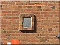
Pear Tree Stores ? datestone
See http://www.geograph.org.uk/photo/5735093 for location.
Image: © Alan Murray-Rust
Taken: 5 Apr 2018
0.06 miles
8
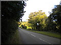
Hamilton Lane north of Scraptoft
Looking north from near the fringe of Scraptoft village, towards Nether Hall. Confusingly, the Scraptoft village sign (right) is double sided.
Image: © Richard Vince
Taken: 13 Oct 2012
0.06 miles
9

Main Street, Scraptoft
This has lost much of its village character with the advent of major housing development round and about. The local Co-operative store still houses a local Post Office.
Image: © Alan Murray-Rust
Taken: 5 Apr 2018
0.07 miles
10

Bench mark, Maomyo, Main Street, Scraptoft
See http://www.geograph.org.uk/photo/5735122 for location.
Image: © Alan Murray-Rust
Taken: 5 Apr 2018
0.11 miles