IMAGES TAKEN NEAR TO
Tilton Road, LEICESTER, LE7 9FE
Introduction
This page details the photographs taken nearby to Tilton Road, LE7 9FE by members of the Geograph project.
The Geograph project started in 2005 with the aim of publishing, organising and preserving representative images for every square kilometre of Great Britain, Ireland and the Isle of Man.

There are currently over 7.5m images from over14,400 individuals and you can help contribute to the project by visiting https://www.geograph.org.uk
Image Map
Images are licensed for reuse under creativecommons.org/licenses/by-sa/2.0
Notes
- Clicking on the map will re-center to the selected point.
- The higher the marker number, the further away the image location is from the centre of the postcode.
Image Listing (7 Images Found)
Images are licensed for reuse under creativecommons.org/licenses/by-sa/2.0
Image
Details
Distance
1
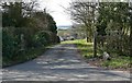
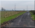
Driveway to Billesdon Lodge
Along the B6047 Melton Road.
Image: © Mat Fascione
Taken: 30 Mar 2008
0.02 miles
2
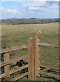
East Leicestershire countryside
Viewed from the B6047 Melton Road.
Image: © Mat Fascione
Taken: 30 Mar 2008
0.06 miles
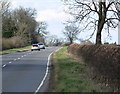
4
B6047 Melton Road
Towards Melton Mowbray.
Image: © Robin Webster
Taken: 18 Jul 2021
0.08 miles
6
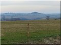
Hills in east Leicestershire
The wooded hill in the centre is the 220m Colborough Hill, with the 230m Whatborough Hill to the left.
Image: © Mat Fascione
Taken: 12 Jan 2013
0.15 miles
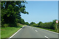
7
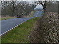
Looking north along the B6047 Melton Road
Image: © Mat Fascione
Taken: 12 Jan 2013
0.19 miles