IMAGES TAKEN NEAR TO
LE7 8AL
Introduction
This page details the photographs taken nearby to LE7 8AL by members of the Geograph project.
The Geograph project started in 2005 with the aim of publishing, organising and preserving representative images for every square kilometre of Great Britain, Ireland and the Isle of Man.

There are currently over 7.5m images from over14,400 individuals and you can help contribute to the project by visiting https://www.geograph.org.uk
Image Map
Images are licensed for reuse under creativecommons.org/licenses/by-sa/2.0
Notes
- Clicking on the map will re-center to the selected point.
- The higher the marker number, the further away the image location is from the centre of the postcode.
Image Listing (25 Images Found)
Images are licensed for reuse under creativecommons.org/licenses/by-sa/2.0
Image
Details
Distance
1
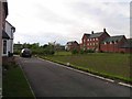
Public Open Space
As there are new trees planted it is assumed that this space will remain as it is and will not be packed with even more little boxes.
Image: © Andrew Tatlow
Taken: 27 May 2013
0.08 miles
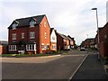
2
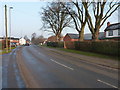
Barkby Road, Syston
Heading into Syston on the road that comes in from Syston Grange, just north of Barkby.
Image: © Richard Law
Taken: 14 Feb 2017
0.08 miles
3
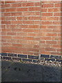
OS benchmark - Syston, 150 Barkby Road
An OS cutmark on the side wall of the house at 150 Barkby Road; originally levelled in 1978 at 59.391m above Ordnance Datum Newlyn.
Image: © Richard Law
Taken: 14 Feb 2017
0.09 miles
4
Benchmark on No. 150 Barkby Road
Ordnance Survey cut mark benchmark described on the Bench Mark Database at www.bench-marks.org.uk/bm82176
Image: © phil Richards
Taken: 21 Sep 2017
0.10 miles
7
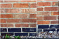
Nos.150 and 148 Barkby Road
There is an Ordnance Survey benchmark Image on the side of the nearer house at its front corner
Image: © phil Richards
Taken: 21 Sep 2017
0.11 miles
8
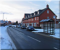
New houses and bus stop on Barkby Road
Image: © Andrew Tatlow
Taken: 9 Jan 2010
0.12 miles
9
John Frear Drive from Eatough Close end
Eatough Close is to the left.
Image: © Andrew Tatlow
Taken: 27 May 2013
0.12 miles
10
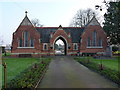
Chapel of Rest, Syston cemetery
Built in 1879, presumably at the same time the cemetery was opened.
Image: © Richard Law
Taken: 14 Feb 2017
0.12 miles