IMAGES TAKEN NEAR TO
Station Road, LEICESTER, LE7 4YX
Introduction
This page details the photographs taken nearby to Station Road, LE7 4YX by members of the Geograph project.
The Geograph project started in 2005 with the aim of publishing, organising and preserving representative images for every square kilometre of Great Britain, Ireland and the Isle of Man.

There are currently over 7.5m images from over14,400 individuals and you can help contribute to the project by visiting https://www.geograph.org.uk
Image Map
Images are licensed for reuse under creativecommons.org/licenses/by-sa/2.0
Notes
- Clicking on the map will re-center to the selected point.
- The higher the marker number, the further away the image location is from the centre of the postcode.
Image Listing (76 Images Found)
Images are licensed for reuse under creativecommons.org/licenses/by-sa/2.0
Image
Details
Distance
1
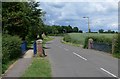
Station Road in Rearsby, Leicestershire
Image: © Mat Fascione
Taken: 15 Jun 2008
0.03 miles
2
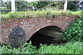
Bridge taking Brookside over stream on east side of Rearsby
Ordnance Survey documents indicate that in 1965 a benchmark levelled at 56.473m above Newlyn Datum was verified on a buttress of this bridge
Image: © phil Richards
Taken: 21 Sep 2017
0.07 miles
3
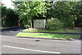
Looking across Station Road towards gas station cabinet
Ordnance Survey documents indicate that in 1965 a rivet benchmark was levelled at 63.267m above Newlyn Datum was verified on a concrete base here.
Image: © phil Richards
Taken: 21 Sep 2017
0.08 miles
4
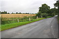
Looking along Brookside towards its junction with Melton Road
Here the road is on bridge of which there is a riverside view at Image
Image: © Roger Templeman
Taken: 11 Sep 2017
0.10 miles
6
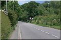
Melton Road in Rearsby, Leicestershire
Image: © Mat Fascione
Taken: 15 Jun 2008
0.11 miles
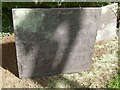
7

Belvoir Angel headstone, Rearsby churchyard
Compared with the other two Belvoir Angel headstones in this churchyard, this one is of the 'standard' pattern. To George Hubbert, d.1712. The inscription shows that he was murdered by being stabbed or cut with a knife.
Image: © Alan Murray-Rust
Taken: 28 Apr 2015
0.11 miles
8

Belvoir Angel headstone, Rearsby churchyard
To Rebecca Stanage, d.1722. One of two 'non-standard' Belvoir Angel headstones in this churchyard. The style of lettering as well as the angel are not typical of the majority of the stones.
Image: © Alan Murray-Rust
Taken: 28 Apr 2015
0.11 miles
9
Belvoir Angel headstone, Rearsby churchyard
Like many Belvoir Angels in the Wreake valley, it does not display the standard style prevalent in the Vale of Belvoir itself. The stone has a pair of stylised angels in the upper corners. To Robert Harrison, d.1711.
Image: © Alan Murray-Rust
Taken: 28 Apr 2015
0.11 miles
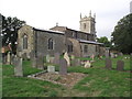
10

St.Michael's church
Eastern view of Rearsby parish church
Image: © Richard Croft
Taken: 24 Oct 2008
0.11 miles