IMAGES TAKEN NEAR TO
Brookhouse Close, LEICESTER, LE7 4YG
Introduction
This page details the photographs taken nearby to Brookhouse Close, LE7 4YG by members of the Geograph project.
The Geograph project started in 2005 with the aim of publishing, organising and preserving representative images for every square kilometre of Great Britain, Ireland and the Isle of Man.

There are currently over 7.5m images from over14,400 individuals and you can help contribute to the project by visiting https://www.geograph.org.uk
Image Map
Images are licensed for reuse under creativecommons.org/licenses/by-sa/2.0
Notes
- Clicking on the map will re-center to the selected point.
- The higher the marker number, the further away the image location is from the centre of the postcode.
Image Listing (107 Images Found)
Images are licensed for reuse under creativecommons.org/licenses/by-sa/2.0
Image
Details
Distance
1
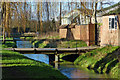
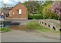
Bridge across Rearsby Brook in Rearsby
Image: © Mat Fascione
Taken: 10 Jan 2016
0.03 miles
3
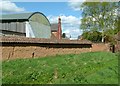
Cob wall at Manor Farm, Rearsby
This is a traditional cob (earth) wall, probably of 18th century date, with a coping of pantiles. Overall it runs to a length of around 150 yards. Some sections have been repaired with brick. Listed Grade II.
Image: © Alan Murray-Rust
Taken: 28 Apr 2015
0.03 miles
4
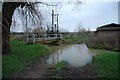
Rearsby Brook
The stream apparently coming in from the right is in fact the beginning of a ford. Rearsby Brook is carrying more water than usual following heavy rain.
Image: © Jonathan Thacker
Taken: 5 Mar 2022
0.03 miles
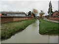
5
Farm Ford at Rearsby
This is the second of the two Rearsby fords.
Image: © John Walton
Taken: 21 Dec 2012
0.04 miles
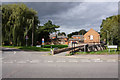
6
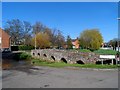
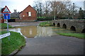
Bridge and ford at Rearsby
The bridge's age is unknown but is perhaps c16. See http://www.britishlistedbuildings.co.uk/en-189541-bridge-rearsby-leicestershire#.VUEu-iFViko for entry in British Listed Buildings
Image: © Bikeboy
Taken: 14 Apr 2015
0.04 miles
7
Ford and bridge at Rearsby
The bridge is a medieval packhorse bridge, likely to be of 16th century origin. Listed Grade II and also a Scheduled Monument. Ford and bridge provide access to Manor Farm and the parish church.
Image: © Alan Murray-Rust
Taken: 28 Apr 2015
0.04 miles
8
Rearsby Ford in Flood
Another image of the Rearsby ford in flood. A very similar image from 2012 can be viewed at:
https://www.geograph.org.uk/photo/3267449
Image: © John Walton
Taken: 13 Oct 2019
0.04 miles
9
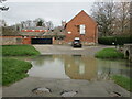
Ford at Rearsby
Adjacent to the medieval bridge. The brook is swollen after heavy rain.
Image: © Jonathan Thacker
Taken: 5 Mar 2022
0.04 miles
10
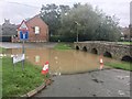
Rearsby Ford
This is the main ford at Church Lane, Rearsby shown here after heavy rain.
There is a second 100 yards down stream.
Image: © John Walton
Taken: 21 Dec 2012
0.04 miles