IMAGES TAKEN NEAR TO
Church Leys Avenue, LEICESTER, LE7 4YF
Introduction
This page details the photographs taken nearby to Church Leys Avenue, LE7 4YF by members of the Geograph project.
The Geograph project started in 2005 with the aim of publishing, organising and preserving representative images for every square kilometre of Great Britain, Ireland and the Isle of Man.

There are currently over 7.5m images from over14,400 individuals and you can help contribute to the project by visiting https://www.geograph.org.uk
Image Map
Images are licensed for reuse under creativecommons.org/licenses/by-sa/2.0
Notes
- Clicking on the map will re-center to the selected point.
- The higher the marker number, the further away the image location is from the centre of the postcode.
Image Listing (80 Images Found)
Images are licensed for reuse under creativecommons.org/licenses/by-sa/2.0
Image
Details
Distance
2
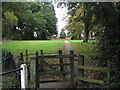
Footpath into Rearsby
The Leicestershire Round footpath into Rearsby, leading off the road from Thrussington. The convent of the Sisters of St Joseph of Peace is visible through trees on the right.
Image: © Tim Heaton
Taken: 30 Sep 2007
0.08 miles
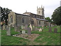
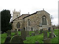
3
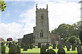
Rearsby Church
St Michael's Church is seen here from the end of Church Leys Avenue. For a different view and some architectural notes see Image
Image: © Stephen McKay
Taken: 23 Jun 2020
0.09 miles
5
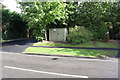
Looking across Station Road towards gas station cabinet
Ordnance Survey documents indicate that in 1965 a rivet benchmark was levelled at 63.267m above Newlyn Datum was verified on a concrete base here.
Image: © phil Richards
Taken: 21 Sep 2017
0.09 miles
6
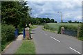
Station Road in Rearsby, Leicestershire
Image: © Mat Fascione
Taken: 15 Jun 2008
0.09 miles
7

Church of St Michael, Rearsby
The south porch, an example of Victorian high Gothic restoration.
Image: © Alan Murray-Rust
Taken: 28 Apr 2015
0.09 miles
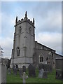
8
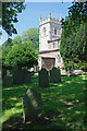
St Michael's Church and churchyard
There is an Ordnance Survey benchmark Image in the middle of the tower face towards the camera
Image: © phil Richards
Taken: 21 Sep 2017
0.09 miles
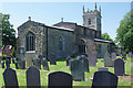
9
Rearsby Church
The tower of St Michael's church seen from over the churchyard wall. The church mainly dates from the late 13th to early 14th century, with Victorian restoration.
Image: © Stephen McKay
Taken: 23 Jun 2020
0.09 miles
10
St Michael's church, Rearsby
Largely of the thirteenth and fourteenth centuries https://historicengland.org.uk/listing/the-list/list-entry/1307375?section=official-list-entry
Image: © Jonathan Thacker
Taken: 5 Mar 2022
0.09 miles