IMAGES TAKEN NEAR TO
Fosse Way, LEICESTER, LE7 4TF
Introduction
This page details the photographs taken nearby to Fosse Way, LE7 4TF by members of the Geograph project.
The Geograph project started in 2005 with the aim of publishing, organising and preserving representative images for every square kilometre of Great Britain, Ireland and the Isle of Man.

There are currently over 7.5m images from over14,400 individuals and you can help contribute to the project by visiting https://www.geograph.org.uk
Image Map
Images are licensed for reuse under creativecommons.org/licenses/by-sa/2.0
Notes
- Clicking on the map will re-center to the selected point.
- The higher the marker number, the further away the image location is from the centre of the postcode.
Image Listing (11 Images Found)
Images are licensed for reuse under creativecommons.org/licenses/by-sa/2.0
Image
Details
Distance

2
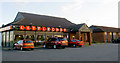
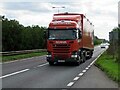
Little Chef and Travelodge on the Leicester bound A46
Image: © Steve Fareham
Taken: 15 Nov 2007
0.00 miles
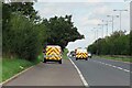
4
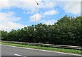
A46 Fosse Way central reservation
The trees between the crash barriers are getting significantly big!
Image: © Andrew Tatlow
Taken: 8 Sep 2020
0.03 miles
5
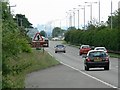
A46 Fosse Way towards Leicester
Close to the Little chef on the south bound side.
Image: © Mat Fascione
Taken: 15 Jun 2008
0.06 miles
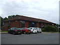
7
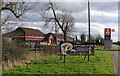
Little Chef and Travelodge Six Hills
Little Chef and Travelodge next to the southbound A46 trunk road near to Six Hills.
Image: © Andrew Tatlow
Taken: 13 Apr 2006
0.07 miles
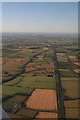
10
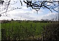
View towards Little Chef across fields
This square is bisected by the A46 trunk road
Image: © Andrew Tatlow
Taken: 13 Apr 2006
0.21 miles