IMAGES TAKEN NEAR TO
Long Furrow, LEICESTER, LE7 3ST
Introduction
This page details the photographs taken nearby to Long Furrow, LE7 3ST by members of the Geograph project.
The Geograph project started in 2005 with the aim of publishing, organising and preserving representative images for every square kilometre of Great Britain, Ireland and the Isle of Man.

There are currently over 7.5m images from over14,400 individuals and you can help contribute to the project by visiting https://www.geograph.org.uk
Image Map
Images are licensed for reuse under creativecommons.org/licenses/by-sa/2.0
Notes
- Clicking on the map will re-center to the selected point.
- The higher the marker number, the further away the image location is from the centre of the postcode.
Image Listing (17 Images Found)
Images are licensed for reuse under creativecommons.org/licenses/by-sa/2.0
Image
Details
Distance
1
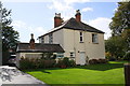
'Broomleigh', Broome Lane
There is an Ordnance Survey benchmark Image on the near left hand corner (facing the drive) of the single storey extension of the house
Image: © Roger Templeman
Taken: 11 Sep 2017
0.06 miles
2
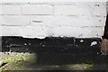
Benchmark on house at bend in Broome Lane
Ordnance Survey cut mark benchmark described on the Bench Mark Database at www.bench-marks.org.uk/bm89527
Image: © Roger Templeman
Taken: 11 Sep 2017
0.07 miles
4
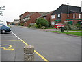
Ling Dale, East Goscote
From the parking spaces opposite St Hilda's Church.
Image: © Kate Jewell
Taken: 6 Sep 2005
0.13 miles
6
St Hilda's church, East Goscote
Built in 1976.
Image: © Jonathan Thacker
Taken: 29 Dec 2024
0.14 miles
8
St Hilda's Church, East Goscote
This 1960's church blends in with the typical architecture of the village.
Image: © Kate Jewell
Taken: 6 Sep 2005
0.15 miles
9
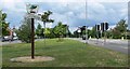
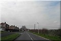
Melton Road in East Goscote, Leicestershire
Image: © Mat Fascione
Taken: 15 Jun 2008
0.16 miles
10
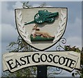
East Goscote village sign
Along Melton Road on the eastern edge of the village.
Image: © Mat Fascione
Taken: 15 Jun 2008
0.16 miles