IMAGES TAKEN NEAR TO
Avenue Road, LEICESTER, LE7 3FA
Introduction
This page details the photographs taken nearby to Avenue Road, LE7 3FA by members of the Geograph project.
The Geograph project started in 2005 with the aim of publishing, organising and preserving representative images for every square kilometre of Great Britain, Ireland and the Isle of Man.

There are currently over 7.5m images from over14,400 individuals and you can help contribute to the project by visiting https://www.geograph.org.uk
Image Map
Images are licensed for reuse under creativecommons.org/licenses/by-sa/2.0
Notes
- Clicking on the map will re-center to the selected point.
- The higher the marker number, the further away the image location is from the centre of the postcode.
Image Listing (22 Images Found)
Images are licensed for reuse under creativecommons.org/licenses/by-sa/2.0
Image
Details
Distance
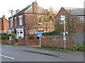
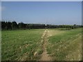
1

#50A Syston Road and bus stop
There is an Ordnance Survey benchmark Image about 1m from the right hand end of the brick wall, left of the bus stop
Image: © Roger Templeman
Taken: 11 Sep 2017
0.09 miles
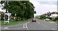
2
Bus stop on Syston Road, Queniborough
Taken specifically to locate the bench mark http://www.geograph.org.uk/photo/3758162 on the wall behind the bus stop pole.
Image: © Alan Murray-Rust
Taken: 22 Nov 2013
0.09 miles
3
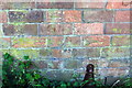
Benchmark on wall in front of #50A Syston Road
Ordnance Survey cut mark benchmark described on the Bench Mark Database at www.bench-marks.org.uk/bm52984
Image: © Roger Templeman
Taken: 11 Sep 2017
0.09 miles
4
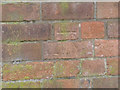
Cut bench mark, outside 50A Syston Road, Queniborough
Much more lightly incised than most, this was a very difficult mark to spot. See http://www.geograph.org.uk/photo/3758167 for location view
Image: © Alan Murray-Rust
Taken: 22 Nov 2013
0.09 miles
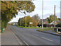
7
Road Junction in Queniborough
Busy road junction of Syston Road, Queniborough Road, Rearsby Road and Barkby Road.
Image: © Mat Fascione
Taken: 16 Jul 2007
0.16 miles
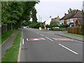
8
Melton Road, Queniborough
The road to the right leads to the old village which is located some distance from the main road.
Image: © Alan Murray-Rust
Taken: 22 Nov 2013
0.16 miles
9
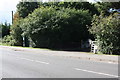
Melton Road
There is a milestone Image beside the white gate
Image: © Roger Templeman
Taken: 11 Sep 2017
0.17 miles
10
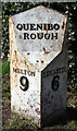
Old Milepost by Melton Road, Queniborough
Cast iron post by the UC road (was A607), in parish of Queniborough (Charnwood District), Melton Road; Three Ways Farm, on the verge, on Northwest side of road. Melton iron casting, erected by the Melton Mowbray turnpike trust in the 19th century.
Inscription reads:-
: MELTON / 9 : : QUENIBO= / =ROUGH : : LEICESTER / 6 :
Grade II listed.
List Entry Number: 1177542 https://historicengland.org.uk/listing/the-list/list-entry/1177542
Milestone Society National ID: LE_MMLE09
Image: © J Higgins
Taken: 1 Nov 2004
0.17 miles