IMAGES TAKEN NEAR TO
Manor Farm Mews, Main Street, LEICESTER, LE7 3EA
Introduction
This page details the photographs taken nearby to Manor Farm Mews, Main Street, LE7 3EA by members of the Geograph project.
The Geograph project started in 2005 with the aim of publishing, organising and preserving representative images for every square kilometre of Great Britain, Ireland and the Isle of Man.

There are currently over 7.5m images from over14,400 individuals and you can help contribute to the project by visiting https://www.geograph.org.uk
Image Map
Images are licensed for reuse under creativecommons.org/licenses/by-sa/2.0
Notes
- Clicking on the map will re-center to the selected point.
- The higher the marker number, the further away the image location is from the centre of the postcode.
Image Listing (73 Images Found)
Images are licensed for reuse under creativecommons.org/licenses/by-sa/2.0
Image
Details
Distance
1
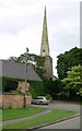
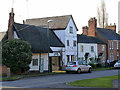
Main Street, Queniborough
The eastern end of Queniborough, seen here near the church, has a rural atmosphere, but further west, where it is effectively an extension of Syston, the village is more suburban in nature.
Image: © Stephen McKay
Taken: 14 Dec 2008
0.05 miles
2
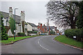
Manor Farm House Queniborough
Parts of this house date back to the 16th century, but with extensions and alterations from around 1700. The range alongside the street possibly formed the original house complete, and is timber framed, with render. Listed Grade II (as No.85 Main Street).
Image: © Alan Murray-Rust
Taken: 22 Nov 2013
0.05 miles
3
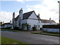
81 Main Street Queniborough
Formerly the vicarage, it faces the church across Main Street. A mid 19th century house with a distinctive aspect due to the central gable in the facade with its bulls-eye window. Listed Grade II.
Image: © Alan Murray-Rust
Taken: 22 Nov 2013
0.05 miles

5
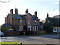
79 to 71 Main Street, Queniborough
According to the local Conservation Area report http://www.charnwood.gov.uk/files/documents/queniborough_conservation_area_appraisal1/queniborough%20conservation%20area%20appraisal%20adopted.doc.pdf these buildings, specifically the nearest one, represent the survivors of the redevelopment of the village in the 13th century. This involved the creation of burgage plots for homesteads and farmsteads on a regular pattern of strips each 1 rod (5½ yards; 5.025m) wide.
The nearest cottage, known as Rupert's Cottage, is essentially 16th century, with a later wing to the rear. It is timber framed, although much of this is concealed by the bush, a central post being visible to the left of the door. The adjacent unit with the large gateway opening (No.77) may have belonged to No.79 at one stage.
No.75 is clearly dated 1703. The pair of cottages beyond, No.73 being a double unit and No.71 a single unit, date from the early 19th century.
All these together form a fine group, and all are Listed Grade II.
Image: © Alan Murray-Rust
Taken: 22 Nov 2013
0.05 miles

8
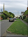
Queniborough, near Leicester
Looking east along Main Street. The church is St Mary's.
Image: © Kate Jewell
Taken: 23 Aug 2005
0.07 miles
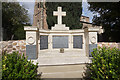
9
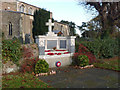
Queniborough War Memorial
Built into the churchyard wall facing Main Street. The centre panels commemorate victims of the First World War, the side panels those from the Second.
Image: © Alan Murray-Rust
Taken: 22 Nov 2013
0.07 miles