IMAGES TAKEN NEAR TO
Main Street, LEICESTER, LE7 3DB
Introduction
This page details the photographs taken nearby to Main Street, LE7 3DB by members of the Geograph project.
The Geograph project started in 2005 with the aim of publishing, organising and preserving representative images for every square kilometre of Great Britain, Ireland and the Isle of Man.

There are currently over 7.5m images from over14,400 individuals and you can help contribute to the project by visiting https://www.geograph.org.uk
Image Map
Images are licensed for reuse under creativecommons.org/licenses/by-sa/2.0
Notes
- Clicking on the map will re-center to the selected point.
- The higher the marker number, the further away the image location is from the centre of the postcode.
Image Listing (73 Images Found)
Images are licensed for reuse under creativecommons.org/licenses/by-sa/2.0
Image
Details
Distance
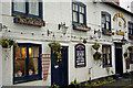
1
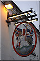
The Britannia, Queniborough
A well-lit sign hangs outside this pub.
Image: © Stephen McKay
Taken: 14 Dec 2008
0.01 miles
2
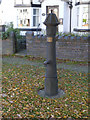
Queniborough village pump
This is a replica of the original pump, installed in 1995 to mark 50 years of peace since the Second World War.
Image: © Alan Murray-Rust
Taken: 22 Nov 2013
0.01 miles
3
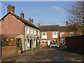
School Lane, Queniborough
Looking towards Main Street with the Horse and Groom on the left.
Image: © Alan Murray-Rust
Taken: 22 Nov 2013
0.03 miles
4
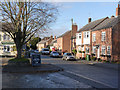
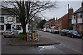
Queniborough, Main Street and former market place
The wide section of Main Street outside the Britannia Inn and the Horse and Groom represents the village market place from the redevelopment of the village in the 13th century.
Image: © Alan Murray-Rust
Taken: 22 Nov 2013
0.03 miles
5
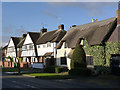
The White House and Tudor Terrace, Queniborough
The White House dates back to the 16th century, but much altered in the 18th, although parts of the original timber frame exist (see http://www.geograph.org.uk/photo/3758161 ). Listed Grade II. Beyond, Tudor Terrace is a distinctive inter-war development of 6 terraced houses in the fashionable Tudorbethan style.
Image: © Alan Murray-Rust
Taken: 22 Nov 2013
0.03 miles
6
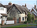
The White House, Queniborough
The White House dates back to the 16th century, but much altered in the 18th. The distinctive cruck frame in the west gable is clearly visible at this time of year when the creeper has lost its leaves. Listed Grade II.
Image: © Alan Murray-Rust
Taken: 22 Nov 2013
0.03 miles
7
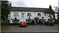
The Britannia
Public House along Main Street in Queniborough.
Image: © Mat Fascione
Taken: 16 Jul 2007
0.03 miles
8
Main Street, Queniborough
There are two pubs here: the Horse & Groom straight ahead and the Britannia out of shot on the left - the Britannia owns the two billboards advertising its Italian nights and Christmas fare.
Image: © Stephen McKay
Taken: 14 Dec 2008
0.03 miles
9
The Horse and Groom, Queniborough
The Horse and Groom is one of two pubs in Queniborough village - the other is the Britannia, next door.
Image: © Stephen McKay
Taken: 14 Dec 2008
0.03 miles
10
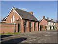
The old school, Queniborough
An attractive 3-bay building from 1847, essentially unaltered. Note the separate boys and girls entrances at either end of the classroom.
Image: © Alan Murray-Rust
Taken: 22 Nov 2013
0.04 miles