IMAGES TAKEN NEAR TO
Dalley Close, LEICESTER, LE7 2LN
Introduction
This page details the photographs taken nearby to Dalley Close, LE7 2LN by members of the Geograph project.
The Geograph project started in 2005 with the aim of publishing, organising and preserving representative images for every square kilometre of Great Britain, Ireland and the Isle of Man.

There are currently over 7.5m images from over14,400 individuals and you can help contribute to the project by visiting https://www.geograph.org.uk
Image Map
Images are licensed for reuse under creativecommons.org/licenses/by-sa/2.0
Notes
- Clicking on the map will re-center to the selected point.
- The higher the marker number, the further away the image location is from the centre of the postcode.
Image Listing (19 Images Found)
Images are licensed for reuse under creativecommons.org/licenses/by-sa/2.0
Image
Details
Distance
1
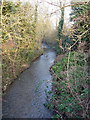
The Barkby Brook at Syston
The brook rises quite a way to the SE of here, in the area between Hungarton Image and Tilton on the Hill Image It runs through Beeby and Barkby, then Syston, and joins the Wreake in Image, a few metres west of the dualled A46.
Image: © Richard Law
Taken: 14 Feb 2017
0.04 miles
2
Pembroke Avenue crosses the Barkby Brook
Image: © Richard Law
Taken: 14 Feb 2017
0.05 miles
3
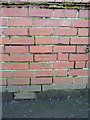
OS benchmark - Syston, bridge on Pembroke Avenue
An OS cutmark on the parapet wall of the bridge over the Barkby Brook; originally levelled in 1978 at 57.283m above Ordnance Datum Newlyn.
Image: © Richard Law
Taken: 14 Feb 2017
0.05 miles
4
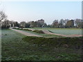
BMX and 'pump' track, De Ville Park
A short BMX cycle track, probably also used as a pump track - a form of cycling in which the rider tries to use the short downhills off each jump to gain extra speed and momentum by 'pumping' the bike down and forwards.
Image: © Richard Law
Taken: 14 Feb 2017
0.10 miles
5
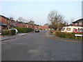
Ruskin Avenue, Syston
Ruskin Avenue seen from the junction with Lincoln Drive.
Image: © Richard Law
Taken: 14 Feb 2017
0.11 miles
6

Cabbage White butterfly basking on Leylandii hedge
There were lots of them. Photographed at maximum zoom on my Canon SX60 when the aberrations sometimes become apparent!
Image: © Andrew Tatlow
Taken: 17 Aug 2019
0.13 miles
7
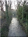
The Barkby Brook - upstream
The brook rises quite a way to the SE of here, in the area between Hungarton Image and Tilton on the Hill Image It runs through Beeby and Barkby, then Syston, and joins the Wreake in Image, a few metres west of the dualled A46.
Image: © Richard Law
Taken: 14 Feb 2017
0.15 miles
8
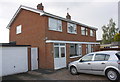
Nos.150 and 148 Barkby Road
There is an Ordnance Survey benchmark Image on the side of the nearer house at its front corner
Image: © phil Richards
Taken: 21 Sep 2017
0.16 miles
9
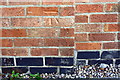
Benchmark on No. 150 Barkby Road
Ordnance Survey cut mark benchmark described on the Bench Mark Database at www.bench-marks.org.uk/bm82176
Image: © phil Richards
Taken: 21 Sep 2017
0.16 miles
10
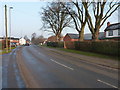
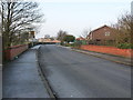
Barkby Road, Syston
Heading into Syston on the road that comes in from Syston Grange, just north of Barkby.
Image: © Richard Law
Taken: 14 Feb 2017
0.17 miles