IMAGES TAKEN NEAR TO
Porritt Way, LEICESTER, LE7 2FP
Introduction
This page details the photographs taken nearby to Porritt Way, LE7 2FP by members of the Geograph project.
The Geograph project started in 2005 with the aim of publishing, organising and preserving representative images for every square kilometre of Great Britain, Ireland and the Isle of Man.

There are currently over 7.5m images from over14,400 individuals and you can help contribute to the project by visiting https://www.geograph.org.uk
Image Map
Images are licensed for reuse under creativecommons.org/licenses/by-sa/2.0
Notes
- Clicking on the map will re-center to the selected point.
- The higher the marker number, the further away the image location is from the centre of the postcode.
Image Listing (10 Images Found)
Images are licensed for reuse under creativecommons.org/licenses/by-sa/2.0
Image
Details
Distance
1
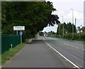
Welcome to Queniborough
Looking northeast along Melton Road.
Image: © Mat Fascione
Taken: 16 Jul 2007
0.08 miles
2
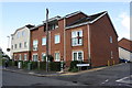
New Brighton Avenue houses at Jack Hardy Close junction
Ordnance Survey documents indicate that in 1965 a benchmark was levelled at 57.084m above Newlyn Datum on a garage at this site.
Image: © Roger Templeman
Taken: 21 Sep 2017
0.13 miles
4

Coles Nursery, Syston
Located on the Wreake floodplain; one of several nursery sites for the UK's "largest grower of trees and shrubs
for the amenity and commercial markets" https://www.colesnurseries.co.uk/
Image: © Tim Heaton
Taken: 1 Feb 2021
0.20 miles

7
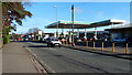
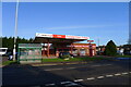
Petrol station on Melton Road, Queniborough
Image: © Mat Fascione
Taken: 10 Jan 2016
0.22 miles
8
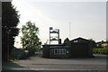
Syston Fire Station
Syston Fire Station, Melton Road, Syston, forms part of the Leicestershire Fire & Rescue Service. This poor shot had to be taken into the evening sunshine
Image: © Kevin Hale
Taken: 29 Apr 2007
0.22 miles
9
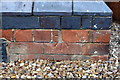
Benchmark on No. 1510 Melton Road
Damaged Ordnance Survey cut mark benchmark described on the Bench Mark Database at www.bench-marks.org.uk/bm52982
Image: © phil Richards
Taken: 21 Sep 2017
0.24 miles
10
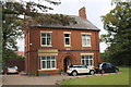
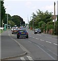
No. 1510 Melton Road, 'The Firs'
There is an Ordnance Survey benchmark Image on the left hand side of the house at its front corner
Image: © phil Richards
Taken: 21 Sep 2017
0.24 miles