IMAGES TAKEN NEAR TO
Mostyn Avenue, LEICESTER, LE7 2ET
Introduction
This page details the photographs taken nearby to Mostyn Avenue, LE7 2ET by members of the Geograph project.
The Geograph project started in 2005 with the aim of publishing, organising and preserving representative images for every square kilometre of Great Britain, Ireland and the Isle of Man.

There are currently over 7.5m images from over14,400 individuals and you can help contribute to the project by visiting https://www.geograph.org.uk
Image Map
Images are licensed for reuse under creativecommons.org/licenses/by-sa/2.0
Notes
- Clicking on the map will re-center to the selected point.
- The higher the marker number, the further away the image location is from the centre of the postcode.
Image Listing (10 Images Found)
Images are licensed for reuse under creativecommons.org/licenses/by-sa/2.0
Image
Details
Distance
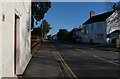
2
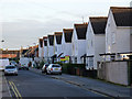
New Brighton Avenue houses at Jack Hardy Close junction
Ordnance Survey documents indicate that in 1965 a benchmark was levelled at 57.084m above Newlyn Datum on a garage at this site.
Image: © Roger Templeman
Taken: 21 Sep 2017
0.12 miles
3
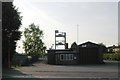
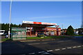
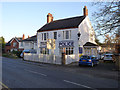
Syston Fire Station
Syston Fire Station, Melton Road, Syston, forms part of the Leicestershire Fire & Rescue Service. This poor shot had to be taken into the evening sunshine
Image: © Kevin Hale
Taken: 29 Apr 2007
0.14 miles
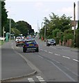
5
Central Avenue, Syston
The houses on the right are built with the distinctive Watchcrete concrete blocks. These were invented by a local manufacturer, Harry Watchorn and appear in a number of locations in the neighbourhood.
Image: © Alan Murray-Rust
Taken: 22 Nov 2013
0.15 miles
6
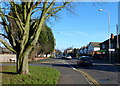
Tree on the corner of Melton Road and Northfields
Image: © Mat Fascione
Taken: 10 Jan 2016
0.17 miles
7
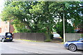
Wooden fence outside No. 1358 Melton Road
Ordnance Survey documents indicate that in 1965 a benchmark levelled at 56.702m above Newlyn Datum was verified on a wall where the fence now is. More information about the mark is at www.bench-marks.org.uk/bm52981
Image: © phil Richards
Taken: 21 Sep 2017
0.17 miles
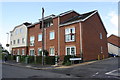
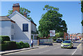
8
Syston Police Station
Clearly not an original location; this was obviously built as a residence.
Image: © Alan Murray-Rust
Taken: 22 Nov 2013
0.24 miles
9
Melton Road, Syston
Looking towards the centre of this Leicestershire town (with a population at the 2011 census of just under 13,000) with the premises of Whitegates Estate Agents on the left. To the right (out of shot) is the health centre.
Image: © Stephen McKay
Taken: 23 Jun 2020
0.24 miles