IMAGES TAKEN NEAR TO
Mallard Drive, LEICESTER, LE7 1ZL
Introduction
This page details the photographs taken nearby to Mallard Drive, LE7 1ZL by members of the Geograph project.
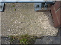
The Geograph project started in 2005 with the aim of publishing, organising and preserving representative images for every square kilometre of Great Britain, Ireland and the Isle of Man.

There are currently over 7.5m images from over14,400 individuals and you can help contribute to the project by visiting https://www.geograph.org.uk
Image Map
Images are licensed for reuse under creativecommons.org/licenses/by-sa/2.0
Notes
- Clicking on the map will re-center to the selected point.
- The higher the marker number, the further away the image location is from the centre of the postcode.
Image Listing (23 Images Found)
Images are licensed for reuse under creativecommons.org/licenses/by-sa/2.0
Image
Details
Distance
1
Fosse Way on bridge over Barkby Brook
There is an Ordnance Survey benchmark Image on the bridge parapet base left of the far parapet pier
Image: © phil Richards
Taken: 21 Sep 2017
0.08 miles
2
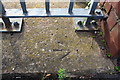
Benchmark on parapet base of Fosse Way bridge over Barkby Brook
Ordnance Survey rivet benchmark described on the Bench Mark Database at www.bench-marks.org.uk/bm69136
Image: © phil Richards
Taken: 21 Sep 2017
0.08 miles
3
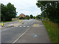
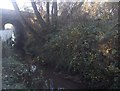
Meadow Lane junction with Fosse Way
Meadown Lane is a narrow access track, bridleway and part of the National Cycle Network route 48, which here runs roughly east/west alongside the Barkby Brook just north of Syston.
Image: © Richard Law
Taken: 15 Jul 2015
0.08 miles
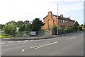
4
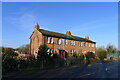
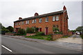
Isolated Victorian terrace, Fosse Way, Syston
Four two-bed properties which appear on the 1884 OS map.
Image: © Tim Heaton
Taken: 1 Feb 2021
0.08 miles
5
OS rivet - Syston, Barkby Brook bridge
An OS rivet and arrow mark in the concrete base of the bridge carrying the Fosse Way over the Barkby Brook. It was originally levelled at 51.213m above Ordnance Datum Newlyn.
Image: © Richard Law
Taken: 15 Jul 2015
0.09 miles
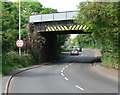
7
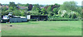
The Midland main line crosses Barkby Brook
Image: © Tim Glover
Taken: 6 Dec 2014
0.10 miles
10
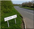
Glebe Way in Syston
At the junction with Meadow Lane.
Image: © Mat Fascione
Taken: 30 Mar 2014
0.13 miles