IMAGES TAKEN NEAR TO
Heath Avenue, LEICESTER, LE7 1YN
Introduction
This page details the photographs taken nearby to Heath Avenue, LE7 1YN by members of the Geograph project.
The Geograph project started in 2005 with the aim of publishing, organising and preserving representative images for every square kilometre of Great Britain, Ireland and the Isle of Man.

There are currently over 7.5m images from over14,400 individuals and you can help contribute to the project by visiting https://www.geograph.org.uk
Image Map
Images are licensed for reuse under creativecommons.org/licenses/by-sa/2.0
Notes
- Clicking on the map will re-center to the selected point.
- The higher the marker number, the further away the image location is from the centre of the postcode.
Image Listing (15 Images Found)
Images are licensed for reuse under creativecommons.org/licenses/by-sa/2.0
Image
Details
Distance
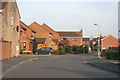
2
Railway embankment, Syston, Leicestershire
This is where the Melton line splits off from the main line to Nottingham. Looking north from the old Meadow Lane with Barkby Brook in the foreground.
Image: © Kate Jewell
Taken: 23 Mar 2006
0.10 miles
3
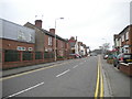
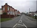
Wanlip Road, Syston
Looking towards the western edge of the town from the junction with Fosse Way.
Image: © Richard Vince
Taken: 11 Mar 2017
0.13 miles
4
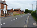
Fosse Way, Syston
A short stretch of the Fosse Way Roman road, which linked Exeter to Lincoln, using one of the straightest routes that the Romans were famed for. The name of the road comes from the latin word 'fossa', a ditch, which may mark the origins of the route as a one-time defensive or boundary structure.
Image: © Richard Law
Taken: 15 Jul 2015
0.14 miles
5
Fosse Way, Syston
The former Roman road towards Lincoln, now rather quiet at this location as Syston is bypassed by the road's modern successor, the A46. Looking north from the junction with Wanlip Road.
Image: © Richard Vince
Taken: 11 Mar 2017
0.15 miles
6
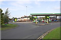
Filling station at Wanlip Road / Fosse Way roundabout
The Wanlip Tollhouse was located at the corner on the far side of the roundabout: in 1856 the building had a benchmark on its southwest angle levelled at 170.1 feet above Liverpool Datum, see www.bench-marks.org.uk/41037
Image: © phil Richards
Taken: 21 Sep 2017
0.16 miles
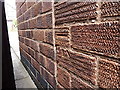
7
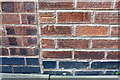
Benchmark on No. 148 Fosse Way
Ordnance Survey cut mark benchmark described on the Bench Mark Database at www.bench-marks.org.uk/bm69137
Image: © phil Richards
Taken: 21 Sep 2017
0.17 miles
8
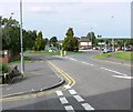
Syston roundabout
At the junction of Fosse Way and Wanlip Road.
Image: © Mat Fascione
Taken: 16 Jul 2007
0.17 miles
9
OS benchmark - Syston, 148 Fosse Way
An OS cutmark on the SW wall of 148 Fosse Way; originally levelled at 50.481m above Ordnance Datum Newlyn in 1965.
Image: © Richard Law
Taken: 15 Jul 2015
0.17 miles
10

Nos. 150 and 148 Fosse Way
There is an Ordnance Survey benchmark Image on the side of the right hand house near the front corner of the original house before its forward extension
Image: © phil Richards
Taken: 21 Sep 2017
0.17 miles