IMAGES TAKEN NEAR TO
Parkstone Road, LEICESTER, LE7 1LY
Introduction
This page details the photographs taken nearby to Parkstone Road, LE7 1LY by members of the Geograph project.
The Geograph project started in 2005 with the aim of publishing, organising and preserving representative images for every square kilometre of Great Britain, Ireland and the Isle of Man.

There are currently over 7.5m images from over14,400 individuals and you can help contribute to the project by visiting https://www.geograph.org.uk
Image Map
Images are licensed for reuse under creativecommons.org/licenses/by-sa/2.0
Notes
- Clicking on the map will re-center to the selected point.
- The higher the marker number, the further away the image location is from the centre of the postcode.
Image Listing (41 Images Found)
Images are licensed for reuse under creativecommons.org/licenses/by-sa/2.0
Image
Details
Distance
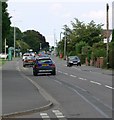
3
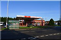
Syston Fire Station
Syston Fire Station, Melton Road, Syston, forms part of the Leicestershire Fire & Rescue Service. This poor shot had to be taken into the evening sunshine
Image: © Kevin Hale
Taken: 29 Apr 2007
0.11 miles
5
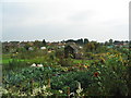
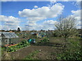
Syston Allotments
Evidently well used, with very little uncultivated ground.
Image: © Tim Heaton
Taken: 14 Oct 2007
0.12 miles
6
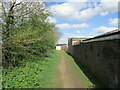
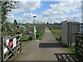
Footpath at Syston
Not marked as a public right of way but well used.
Image: © Jonathan Thacker
Taken: 8 Apr 2022
0.13 miles
8
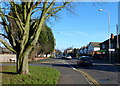
Tree on the corner of Melton Road and Northfields
Image: © Mat Fascione
Taken: 10 Jan 2016
0.13 miles

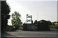
10
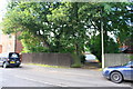
Wooden fence outside No. 1358 Melton Road
Ordnance Survey documents indicate that in 1965 a benchmark levelled at 56.702m above Newlyn Datum was verified on a wall where the fence now is. More information about the mark is at www.bench-marks.org.uk/bm52981
Image: © phil Richards
Taken: 21 Sep 2017
0.15 miles