IMAGES TAKEN NEAR TO
Flatten Way, LEICESTER, LE7 1GU
Introduction
This page details the photographs taken nearby to Flatten Way, LE7 1GU by members of the Geograph project.
The Geograph project started in 2005 with the aim of publishing, organising and preserving representative images for every square kilometre of Great Britain, Ireland and the Isle of Man.

There are currently over 7.5m images from over14,400 individuals and you can help contribute to the project by visiting https://www.geograph.org.uk
Image Map
Images are licensed for reuse under creativecommons.org/licenses/by-sa/2.0
Notes
- Clicking on the map will re-center to the selected point.
- The higher the marker number, the further away the image location is from the centre of the postcode.
Image Listing (69 Images Found)
Images are licensed for reuse under creativecommons.org/licenses/by-sa/2.0
Image
Details
Distance
1
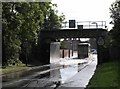
High Street Railway Bridge Flood
This stretch of road frequently floods after rain.
Image: © Andrew Tatlow
Taken: 2 Oct 2006
0.05 miles
3
Railway bridge crossing the High Street in Syston
Image: © Mat Fascione
Taken: 12 Oct 2014
0.10 miles

5

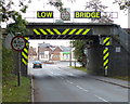
High Street railway bridge
The deck has clearly been modernised at some stage, but headroom remains restricted. There is a bench mark http://www.geograph.org.uk/photo/3760306 on the right hand abutment under the deck.
Image: © Alan Murray-Rust
Taken: 22 Nov 2013
0.10 miles
6
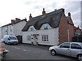
Stone House, Turn Street, Syston
The appearance of this house was completely changed with a rebuilding in 1904, when it was converted into one house from two cottages. The core of the cottage probably dates from the 17th century. Listed Grade II.
Turn Street is shown on the 1884 1:2500 map as 'Turnagain Lane'; then as now it was a dead end.
Image: © Alan Murray-Rust
Taken: 22 Nov 2013
0.10 miles
7

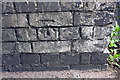
Bench mark, High Street railway bridge
Cut mark on the northern abutment, which has clearly been overpainted several times. The white area is a warning of the fact that the bridge is quite narrow. See http://www.geograph.org.uk/photo/3760303 for location.
Image: © Alan Murray-Rust
Taken: 22 Nov 2013
0.10 miles
8
Benchmark on railway bridge wall on NE side High Street
Ordnance Survey cut mark benchmark described on the Bench Mark Database at www.bench-marks.org.uk/bm52973
Image: © phil Richards
Taken: 21 Sep 2017
0.10 miles
9
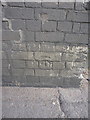
OS benchmark - Syston, High St railway bridge
An OS cutmark low on the buttress wall of the railway bridge; originally levelled at 50.579m above Ordnance Datum Newlyn.
Image: © Richard Law
Taken: 17 Mar 2016
0.11 miles
10

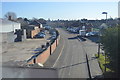
Sheltered accommodation, Turn Street
A group of 7 dwellings around a small green.
Image: © Alan Murray-Rust
Taken: 22 Nov 2013
0.11 miles