IMAGES TAKEN NEAR TO
Riverdale Close, LEICESTER, LE7 1FZ
Introduction
This page details the photographs taken nearby to Riverdale Close, LE7 1FZ by members of the Geograph project.
The Geograph project started in 2005 with the aim of publishing, organising and preserving representative images for every square kilometre of Great Britain, Ireland and the Isle of Man.

There are currently over 7.5m images from over14,400 individuals and you can help contribute to the project by visiting https://www.geograph.org.uk
Image Map
Images are licensed for reuse under creativecommons.org/licenses/by-sa/2.0
Notes
- Clicking on the map will re-center to the selected point.
- The higher the marker number, the further away the image location is from the centre of the postcode.
Image Listing (114 Images Found)
Images are licensed for reuse under creativecommons.org/licenses/by-sa/2.0
Image
Details
Distance
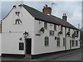
1

The Dog and Gun, Chapel Street, Syston
Public house now run by the Steamin' Billy Brewing Co, a small Leicestershire-based brewery founded in 1995.
Image: © Alan Murray-Rust
Taken: 22 Nov 2013
0.01 miles
2

Inn sign at the Dog and Gun, Syston
The dog is Billy of the brewery name, only coincidentally referring to the pub's own name.
Image: © Alan Murray-Rust
Taken: 22 Nov 2013
0.01 miles
3
Syston Dog & Gun
28 Chapel Street. Part of the small Steamin' Billy group since 2011.
Image: © the bitterman
Taken: 31 Mar 2012
0.02 miles
4
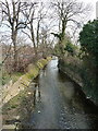
Barkby Brook from Broad Street
The greatly canalised brook that runs through the centre of Syston, looking in the opposite direction to the view in Image
Image: © Richard Law
Taken: 17 Mar 2016
0.03 miles
5
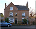
19 Chapel Street, Syston
Early 18th century. The asymmetrical front with a gable is untypical of the period. Listed Grade II.
Image: © Alan Murray-Rust
Taken: 22 Nov 2013
0.04 miles
6
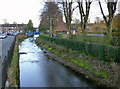
Barkby Brook at Brookside, Syston
The local Conservation Area appraisal comments on the heavily engineered course of the stream, but notes that it still provides a valuable wildlife corridor through the urban area. Central Park to the right.
Image: © Alan Murray-Rust
Taken: 22 Nov 2013
0.05 miles
7
The old chapel, Chapel Street, Syston
Not shown as 'Chapel' on OS maps after the 1884 edition, after which time the current Wesleyan Methodist chapel on High Street had been built. Later shown as Sunday School. This suggests that it was the precursor to the current Wesleyan Methodist chapel. Now occupied by SARIC (Syston Arts and Recreation in the Community).
Image: © Alan Murray-Rust
Taken: 22 Nov 2013
0.05 miles
8
2 Brook Street, Syston
A small 2-bay house from the early 19th century in brick with a Swithland slate roof. Listed Grade II.
Image: © Alan Murray-Rust
Taken: 22 Nov 2013
0.07 miles
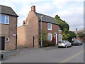
9

5 and 3 Chapel Street, Syston
Vine House and Chatsley House respectively. These are a pair of Georgian (late 18th century) town houses, built in the locally favoured Flemish bond with contrasting headers. The nearer shows a desire for economy by the original owner by having the central windows blank, thus reducing the amount of window tax http://en.wikipedia.org/wiki/Window_tax . Both houses are Listed Grade II.
Image: © Alan Murray-Rust
Taken: 22 Nov 2013
0.07 miles
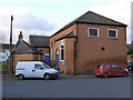
10

Syston Town Council Community Centre
A re-use of the old town senior school.
Image: © Alan Murray-Rust
Taken: 22 Nov 2013
0.07 miles