IMAGES TAKEN NEAR TO
Ashby Road, COALVILLE, LE67 8UH
Introduction
This page details the photographs taken nearby to Ashby Road, LE67 8UH by members of the Geograph project.
The Geograph project started in 2005 with the aim of publishing, organising and preserving representative images for every square kilometre of Great Britain, Ireland and the Isle of Man.

There are currently over 7.5m images from over14,400 individuals and you can help contribute to the project by visiting https://www.geograph.org.uk
Image Map
Images are licensed for reuse under creativecommons.org/licenses/by-sa/2.0
Notes
- Clicking on the map will re-center to the selected point.
- The higher the marker number, the further away the image location is from the centre of the postcode.
Image Listing (8 Images Found)
Images are licensed for reuse under creativecommons.org/licenses/by-sa/2.0
Image
Details
Distance
1
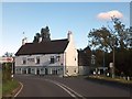
The George and Dragon inn on A512
This inn is on the main road (Ashby to Loughborough) a little way out of the village.
Image: © David Smith
Taken: 16 Oct 2012
0.05 miles
2
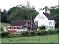
The George and Dragon
The George and Dragon was a 19th century pub which, in recent years, has concentrated more on the restaurant trade.
Image: © Ian Calderwood
Taken: 23 Jul 2010
0.08 miles
5
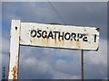
Finger Post
Wooden finger with plastic letters tacked on fastened to a piece of angle iron stuck in the ground.
Image: © Andrew Tatlow
Taken: 7 Sep 2006
0.15 miles
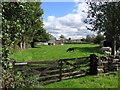
8
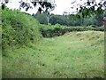
Dry Canal Bed
This section of dry canal bed is close to its terminus at Thringston, behind Cinder Hill Farm.
Image: © Ian Calderwood
Taken: 23 Jul 2010
0.22 miles