IMAGES TAKEN NEAR TO
Field Close, COALVILLE, LE67 8PU
Introduction
This page details the photographs taken nearby to Field Close, LE67 8PU by members of the Geograph project.
The Geograph project started in 2005 with the aim of publishing, organising and preserving representative images for every square kilometre of Great Britain, Ireland and the Isle of Man.

There are currently over 7.5m images from over14,400 individuals and you can help contribute to the project by visiting https://www.geograph.org.uk
Image Map
Images are licensed for reuse under creativecommons.org/licenses/by-sa/2.0
Notes
- Clicking on the map will re-center to the selected point.
- The higher the marker number, the further away the image location is from the centre of the postcode.
Image Listing (9 Images Found)
Images are licensed for reuse under creativecommons.org/licenses/by-sa/2.0
Image
Details
Distance
1
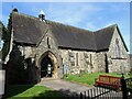
The Parish Church of St. Andrew
Opened in 1862, St. Andrew's is part of the Anglican Diocese of Leicester. The building is Grade II listed.
Image: © Ian Calderwood
Taken: 4 Apr 2021
0.08 miles
2
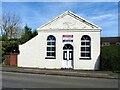
Thringstone Methodist Church
Opened in 1863 as a Primitive Methodist chapel and now part of the National Forest East Methodist Circuit.
Image: © Ian Calderwood
Taken: 4 Apr 2021
0.16 miles
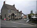
4
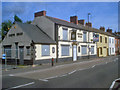
The Queens Head
A Marstons pub, situated on The Green. The pub closed in August 2008 and still sports a 'for sale' sign a year later.
Image: © Trevor Rickard
Taken: 29 Aug 2009
0.19 miles
5
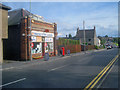
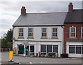
Thringstone Post Office
Situated on The Green. Post office, off licence, newsagents, and does a nice line in potted plants.
Image: © Trevor Rickard
Taken: 29 Aug 2009
0.19 miles
6
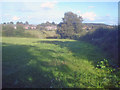
Public footpath to Thringstone
Public footpaths criss-cross this area in abundance. This one hugs the hedgerow in an easterly direction to Thringstone a couple of fields away.
Image: © Trevor Rickard
Taken: 29 Aug 2009
0.24 miles
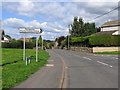
8
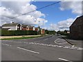
West end of Gracedieu Road, Thringstone
Seen at its junction with Talbot Street on the southern edge of Thringstone. Gracedieu was a nearby priory, some of whose ruined walls still stand.
Image: © Richard Vince
Taken: 27 Mar 2013
0.25 miles