IMAGES TAKEN NEAR TO
Valley View, COALVILLE, LE67 8PL
Introduction
This page details the photographs taken nearby to Valley View, LE67 8PL by members of the Geograph project.
The Geograph project started in 2005 with the aim of publishing, organising and preserving representative images for every square kilometre of Great Britain, Ireland and the Isle of Man.

There are currently over 7.5m images from over14,400 individuals and you can help contribute to the project by visiting https://www.geograph.org.uk
Image Map
Images are licensed for reuse under creativecommons.org/licenses/by-sa/2.0
Notes
- Clicking on the map will re-center to the selected point.
- The higher the marker number, the further away the image location is from the centre of the postcode.
Image Listing (12 Images Found)
Images are licensed for reuse under creativecommons.org/licenses/by-sa/2.0
Image
Details
Distance
1
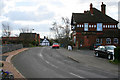
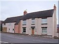
The Cross Keys, Newbold
On Worthington Lane, the main street through Newbold,1900, lists William Crabtree as the Keeper of the Cross Keys Public House.
Image: © Kate Jewell
Taken: 21 Mar 2007
0.06 miles
2
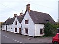
Elms Farmhouse
Elms Farmhouse is Grade 2 listed.
Image: © Ian Calderwood
Taken: 31 Oct 2014
0.09 miles
3
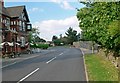
Worthington Lane in Newbold
The building on the left is The Cross Keys pub.
Image: © Mat Fascione
Taken: 26 Jul 2008
0.10 miles
4
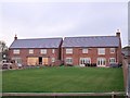
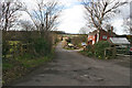
New build at Newbold
Some expensive-looking housing nearing completion in what was the yard at Newbold Farm.
Image: © Ian Calderwood
Taken: 31 Oct 2014
0.10 miles
5
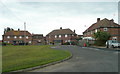
Cloud Hill View
Evocative name for a cul-de-sac of council houses at the north end of Newbold.
Image: © Jonathan Billinger
Taken: 13 Jun 2008
0.11 miles
6
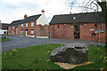
Newbold, Leicestershire
This road junction is just inside the featured square according to the 1:25,000 OS map. The main village street is Worthington Lane to the left and School Lane to the right. The street joining at the junction is Ashby Road. The large boulder is of the local stone; there are numerous quarries in the area, both working and disused, the nearest being at Cloud Hill in Image
Image: © Kate Jewell
Taken: 21 Mar 2007
0.11 miles
8
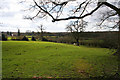
Farmland at Newbold
Just off Worthington Lane and Pipeyard Lane this countryside falls away to the line of an old railway. The farm in the distance is in Image
Image: © Kate Jewell
Taken: 21 Mar 2007
0.12 miles
9
Pipeyard Lane, Newbold
A quiet lane leading from the peaceful village of Newbold to an industrial estate, once the site of the Newbold Pipe Works.
Image: © Kate Jewell
Taken: 21 Mar 2007
0.14 miles
10
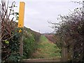
Ivanhoe Way
The Ivanhow Way is a 36 mile circular walk in Leicestershire which skirts around Newbold on its way North towards Worthington. The church at Breedon on the Hill is visible in the distance.
Image: © Ian Calderwood
Taken: 31 Oct 2014
0.17 miles