IMAGES TAKEN NEAR TO
Stoney Lane, COALVILLE, LE67 8JJ
Introduction
This page details the photographs taken nearby to Stoney Lane, LE67 8JJ by members of the Geograph project.
The Geograph project started in 2005 with the aim of publishing, organising and preserving representative images for every square kilometre of Great Britain, Ireland and the Isle of Man.

There are currently over 7.5m images from over14,400 individuals and you can help contribute to the project by visiting https://www.geograph.org.uk
Image Map
Images are licensed for reuse under creativecommons.org/licenses/by-sa/2.0
Notes
- Clicking on the map will re-center to the selected point.
- The higher the marker number, the further away the image location is from the centre of the postcode.
Image Listing (10 Images Found)
Images are licensed for reuse under creativecommons.org/licenses/by-sa/2.0
Image
Details
Distance
1
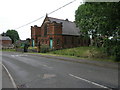
Primitive Methodist Church
This Methodists church in Coleorton has these two unusual towers at its west end rather than the more plain building front that we see.
Image: © Michael Patterson
Taken: 12 Jun 2006
0.11 miles
4
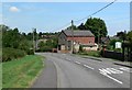
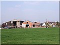
Coleorton
The Coleorton Methodist Church is visible in the distance.
Image: © Andrew Tatlow
Taken: 20 Jun 2006
0.15 miles
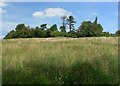
5
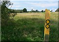
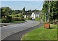
Public footpaths near Coleorton
Looking west from Lower Moor Road.
Image: © Mat Fascione
Taken: 26 Jul 2008
0.16 miles
7
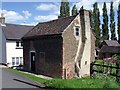
Frances Cottage
Frances Cottage is a rare survivor of the type of tiny house that ordinary people would once have lived in.
Image: © Ian Calderwood
Taken: 7 Jun 2015
0.20 miles
8
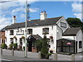
Coleorton George Inn
Pub alongside the A512
Image: © the bitterman
Taken: 21 Jul 2010
0.22 miles
10
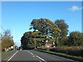
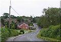
A512 in Coleorton
Some fine trees at the crest of the hill from Ashby
Image: © David Smith
Taken: 16 Oct 2012
0.23 miles