IMAGES TAKEN NEAR TO
The Moor, COALVILLE, LE67 8GF
Introduction
This page details the photographs taken nearby to The Moor, LE67 8GF by members of the Geograph project.
The Geograph project started in 2005 with the aim of publishing, organising and preserving representative images for every square kilometre of Great Britain, Ireland and the Isle of Man.

There are currently over 7.5m images from over14,400 individuals and you can help contribute to the project by visiting https://www.geograph.org.uk
Image Map
Images are licensed for reuse under creativecommons.org/licenses/by-sa/2.0
Notes
- Clicking on the map will re-center to the selected point.
- The higher the marker number, the further away the image location is from the centre of the postcode.
Image Listing (3 Images Found)
Images are licensed for reuse under creativecommons.org/licenses/by-sa/2.0
Image
Details
Distance
1
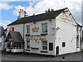
Coleorton Moor Kings Arms
The Moor. Now under the same ownership as the Tap House at Smisby.
Image: © the bitterman
Taken: 21 Jul 2010
0.04 miles
2
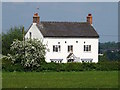
The former Queen's Head Inn
The Queen's Head stopped being an inn some time in the late 19th or early 20th century.
Image: © Ian Calderwood
Taken: 27 May 2016
0.17 miles
3
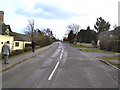
Coleorton Moor, looking south towards Pitt Lane
Coleorton Moor, looking south from near The Angel Inn, with Pilgrim Cottage on the left, up towards Pitt Lane a couple of hundred yards up on the right. Going on past Pitt Lane, the Moor itself leads on to Sinope and the curiously named Botany Bay. The whole area of Coleorton, and particularly in the village itself, is literally festooned with public footpaths that criss-cross the surrounding fields enough to show the red-dotted lines quite densely on Ordnance Survey maps.
Image: © Robert Haywood
Taken: Unknown
0.23 miles