IMAGES TAKEN NEAR TO
Jones Close, COALVILLE, LE67 8AE
Introduction
This page details the photographs taken nearby to Jones Close, LE67 8AE by members of the Geograph project.
The Geograph project started in 2005 with the aim of publishing, organising and preserving representative images for every square kilometre of Great Britain, Ireland and the Isle of Man.

There are currently over 7.5m images from over14,400 individuals and you can help contribute to the project by visiting https://www.geograph.org.uk
Image Map
Images are licensed for reuse under creativecommons.org/licenses/by-sa/2.0
Notes
- Clicking on the map will re-center to the selected point.
- The higher the marker number, the further away the image location is from the centre of the postcode.
Image Listing (14 Images Found)
Images are licensed for reuse under creativecommons.org/licenses/by-sa/2.0
Image
Details
Distance
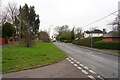
1
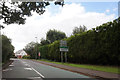
Griffin Road
This road is on the northern edge of the village of Thringstone.
Image: © Malcolm Neal
Taken: 10 Feb 2023
0.09 miles
2
Griffin Road off Loughborough Road, Thringstone
Image: © Ian S
Taken: 30 Aug 2020
0.11 miles
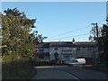
4
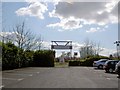
Entrance to Grace Dieu Cricket Club
From the Bulls Head Public House car park.
Image: © Steve Fareham
Taken: 17 Apr 2008
0.16 miles
5
Loughborough Road
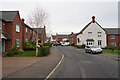
Standing in Springfield looking along the Loughborough Road in the village of Thringstone.
Image: © Malcolm Neal
Taken: 10 Feb 2023
0.16 miles
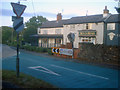
6
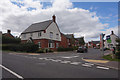
The Bull's Head Inn on A512
A large inn on the main road, just outside the village
Image: © David Smith
Taken: 16 Oct 2012
0.17 miles
7
The Bulls Head
Situated on Loughborough Road at its junction with the main A512 Ashby Road. Large country pub, parts of which date back to 1777.
Image: © Trevor Rickard
Taken: 29 Aug 2009
0.19 miles
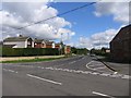
9
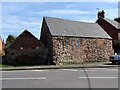
Former blacksmiths and meeting house
According to the blue plaque, this building was once a blacksmiths and a Primitive Methodist meeting house.
Image: © Ian Calderwood
Taken: 4 Apr 2021
0.21 miles
10
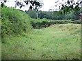
Dry Canal Bed
This section of dry canal bed is close to its terminus at Thringston, behind Cinder Hill Farm.
Image: © Ian Calderwood
Taken: 23 Jul 2010
0.23 miles